Download Waze Navigation & Live Traffic v4.100.0.0 RC

Waze Navigation & Live Traffic v4.100.0.0 RC
Requirements: 7.0+
Overview: Waze is the world’s largest community-based traffic and navigation app. Join drivers in your area who share real-time traffic & road info to save time, gas money, and improve daily commuting for all.

Image

Just by driving with Waze open, you’re already contributing tons of real-time traffic information to your local community. You can also actively report accidents, police traps and other hazards you see on the road. Get road alerts along your route and find the cheapest gas prices around you shared by the community. Plus, you can add friends, send locations or keep others posted on your arrival time.

– Live routing based on community driven, real-time traffic & road info
– Community reported alerts including accidents, hazards, police traps, road closures, and more
– Turn-by-turn voice guided navigation
– Live maps, consistently edited and updated by Waze community map editors
– Automatic rerouting as conditions change on the road
– Send your ETA & real-time drive to update those you’re meeting
– Learns your frequent destinations, commuting hours, and preferred routes
– Find the cheapest gas station on your route
– Add information on local places and businesses
– Add Facebook friends and sync Contacts
– See friends’ ETA when driving to the same destination
– One tap navigation to Facebook & Calendar events
– Earn points as you contribute road info and climb the ranks in your community

Waze is all about contributing to and benefiting from the common good, so hop on board and get involved!

Note: Continued use of GPS running in the background can dramatically decrease battery life. Waze will automatically shut down if you run it in the background and haven’t driven for a while.

Learn more about the Waze privacy policy, including what information is accessed and how it is used. With Waze, you have full control over your privacy settings. _http://www.waze.com/legal/privacy/

★ Untouched apk with Original Hash Signature
★ Certificate MD5 digest: 973cbf4c6cc7c602486328f140c781ea
★ No changes were applied
➡ Languages: Full Multi Languages
➡ CPU architectures: arm64-v8a, armeabi-v7a
➡ Screen DPIs: 120dpi, 160dpi, 240dpi, 320dpi, 480dpi, 640dpi


What’s New:
New RC 4.100.0.0 release. Please visit Waze Discuss for full release notes and to submit your feedback.

What’s new?
– We’re adding specific alerts on the map to help you navigate safer.

Fixed:
– Changing voice with street names not working properly (WD-24152)
– Waze Android Beta Toll Price Error (WD-24173)
– Stability and crash fixes

This app has banner advertisements

More Info:
https://play.google.com/store/apps/details?id=com.waze

Download Instructions:
https://ouo.io/1SlRDD

Mirror:
https://ouo.io/GVSoA6
https://ouo.io/SwCYC1
https://rapidgator.net/file/3e0012ab0b6 … 7.apk.html.
Download PeakFinder v4.7.32 [Paid] [Patched] [Mod Extra]

PeakFinder v4.7.32 [Paid] [Patched] [Mod Extra]
Requirements: 5.1+
Overview: The mountains are calling! Explore more mountains than any mountaineer! PeakFinder AR makes it possible… and shows the names of all mountains and peaks with a 360° panorama display.

Image

This functions completely offline – and worldwide!
PeakFinder knows more than 650’000 peaks – from Mount Everest to the little hill around the corner.

•••••••••
Winner of several prizes. Highly recommended by nationalgeographic.com, androidpit.com, smokinapps.com, outdoor-magazin.com, themetaq.com, digital-geography.com, …
•••••••••

••• Features •••
• Works offline and worldwide
• Includes more than 650’000 peak names
• Overlays the camera image with the panorama drawing *
• Realtime rendering of the surrounding landscapes in a range of 300km/200mil
• Digital telescope to select less prominent peaks
• ‘Show me’-function for visible peaks
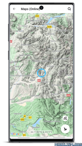
• Selection of the viewpoint by GPS, the peak directory or an (online) map
• Can fly like a bird from peak to peak and vertically upwards
• Shows the solar and lunar orbit with rise and set times
• Uses compass and motion sensors
• Weekly updates of the peak directory
* On devices without a gyroscope and a compass sensor the camera mode is not supported.

What’s New:
– Fixed an error in the visiblity calculations.
– Various performance improvements and bug fixes.

Mod Info:
  • No root or Lucky Patcher or Google Play Modded required;
  • Disabled / Removed unwanted Permissions + Receivers + Providers + Services;
  • Optimized and zipaligned graphics and cleaned resources for fast load;
  • Google Maps Locations works;
  • Google Play Store install package check disabled;
  • Debug code removed;
  • Remove default .source tags name of the corresponding java files;
  • Analytics / Crashlytics / Firebase disabled;
  • Languages: Full Multi Languages;
  • CPUs: armeabi-v7a, arm64-v8a, x86, x86_64;
  • Screen DPIs: 160dpi, 240dpi, 320dpi, 480dpi, 640dpi;
  • Original package signature changed;
  • Release by Balatan.


This app has no advertisements

More Info:
https://play.google.com/store/apps/details?id=org.peakfinder.area.alps

Download Instructions:
https://ouo.io/yVn879

Mirrors:
https://ouo.io/Xqsfyi
https://ouo.io/VLMJPn
https://ouo.io/mx68RT0
https://ouo.io/nCE8FSz
https://ouo.io/hguBvo
https://ouo.io/rzOFlPA.

Download Gaia GPS: Offroad Hiking Maps v2023.11 [Subscribed] [Mod Extra]

Gaia GPS: Offroad Hiking Maps v2023.11 [Subscribed] [Mod Extra]
Requirements: 6.0+
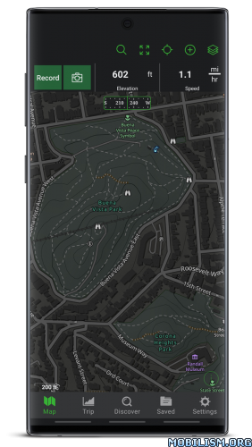
Overview: Navigate, track, and explore with Gaia GPS. Millions of people worldwide use Gaia GPS maps to backpack, hike, hunt, camp, ski, and explore the backroads.

ImageImage

Gaia GPS has been featured in countless publications, including Outside, Backpacker, Trail Runner, and the New York Times.

►► Backpacking

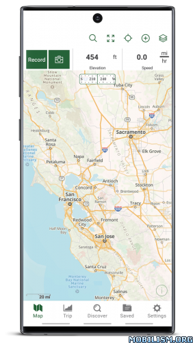
Gaia GPS is first and foremost a backpacking app. View your route using comprehensive topo maps and backpacking map layers, plus up-to-date weather forecast overlays. Then, use the intelligent routing tools to plan trips, mark campsites and points of interest, and measure distance, altitude, and elevation change.

►► Day Hiking

Both a hiking navigation app and a platform for finding hikes, Gaia GPS helps you discover your next adventure. You can also create your own tracks, leave reviews, and contribute to the community-sourced hike database.

►► Hunting

Gaia GPS is the most comprehensive hunting app on the market. Build custom hunting maps by cross-referencing game management units with public and private land parcels. Then, get deep into the wilderness to find solitude, even on opening day, with the Roadless and Roadless/Trailless overlays.

►► Camping and Overlanding

A camping app with weather forecasts, public land data, and community-sourced camping beta, Gaia GPS helps you find a campsite anywhere. View dispersed camping areas on the Public Land overlay, and leave waypoints to create custom camping maps. Reference road maps and MVUMs to plot overland, 4×4, or off-roading routes.

►► Backcountry Skiing and Mountaineering

Apply slope-angle shading and 24-, 48-,and 72-hour Snowfall and Precipitation Forecast overlays to create custom backcountry skiing maps, plan tours, and avoid avalanche terrain. Gaia GPS is the best skiing app for staying safe deep in the backcountry.

►► Mountain Biking

Go farther, faster by mounting Gaia GPS to your handlebars for hands-free navigation. Access mountain biking trail maps on both public and private land with the best mountain biking app on the market.

►► Professional Use: Firefighters, Search and Rescue teams, Land Manager, GIS Techs, and Guides

Gaia GPS is the preferred nav app for outdoor professionals. Quickly route to GPS coordinates, view recent wildfires, and share maps, tracks, and waypoints with your team to get boots on the ground faster. Guides can mark routes, campsites, and water sources, and share hard-to-find approaches and descents with clients and fellow guides.

►► Membership Levels

Free Level – You’ll be limited to the default map source, and you won’t be able to download maps for offline use.
Member Level – As a Member, you can download a worldwide catalog of topo, road, and satellite maps.
Premium Member Level – As a Premium Member, you also get access to these map sources:

• NatGeo Trails Illustrated (including Appalachian Trail, Colorado Trail, and John Muir Trail maps)
• ESRI World Satellite Imagery
• NOAA weather forecasts
• US Private Land Ownership (including owner names and addresses for parcels)
• US Hunting Layers (including GMUs, public land, and recent fires)
• US Motor Vehicle Use Maps (MVUMs)
• France IGN
• Swiss Topo
• Backroads Mapbooks Canada
• Hill-shading, contour-line, slope-angle, and other overlays

► To manage your subscription:
• TURN OFF auto-renewal: https://support.google.com/googleplay/answer/7018481

• Subscriptions automatically renew unless auto-renew is turned off at least 24 hours before the end of the current period. Your Google Play account will be charged for renewal within 24 hours of the end of the current period, and identify the cost of the renewal.

• Your Google Play Account will be charged at confirmation of purchase.

• Visit the following URL to view our Privacy Policy: http://www.gaiagps.com/gaiacloud-terms/

• Visit the following URL for full terms of use: http://www.gaiagps.com/terms_of_use

What’s New:
Version 2023.11 addresses a Play Store compliance issue regarding the subscription purchase page.

Release notes from 2023.10:
New
– Option in Android Auto to disable 3D in Course Up mode
– Settings to configure what tapping and long tapping on map do
Fixed
– Issue causing some map downloads to be completely deleted
A few rare crashes and minor bugs

Mod Info:
  • Premium / Paid features unlocked;
  • Disabled / Removed unwanted Permissions + Receivers + Providers + Services;
  • Optimized and zipaligned graphics and cleaned resources for fast load;
  • Ads Permissions / Services / Providers removed from Android.manifest;
  • Ads links removed and invokes methods nullified;
  • Ads layouts visibility disabled;
  • Google Play Store install package check disabled;
  • Debug code removed;
  • Remove default .source tags name of the corresponding java files;
  • Analytics / Crashlytics / Firebase disabled;
  • Native Sentry code removed and disabled;
  • AOSP compatible mode;
  • Languages: Full Multi Languages;
  • CPUs: armeabi-v7a, arm64-v8a, x86, x86_64;
  • Screen DPIs: 120dpi, 160dpi, 240dpi, 320dpi, 480dpi, 640dpi;
  • Original package signature changed;
  • Release by Balatan.


This app has no advertisements

More Info:
https://play.google.com/store/apps/details?id=com.trailbehind.android.gaiagps.pro

Download Instructions:
https://ouo.io/Lpn7FCJ

Mirrors:
https://ouo.io/MPe26
https://ouo.io/WQPpfN
https://ouo.io/rnQrbF
https://ouo.io/GNFQhxm
https://ouo.io/zeFNoGd
https://ouo.io/SWi0T1.

Download bergfex Hiking & Tracking v4.12.0 [Pro]

bergfex Hiking & Tracking v4.12.0 [Pro]
Requirements: 7.0+
Overview: The perfect ALL-IN-ONE tool for all your outdoor activities. Use it for Hiking, Mountain Biking, Running, Cycling, Climbing, Nordic walking, Ski Tours, Fitness and much more.

Image

Outdoor Tracking & Tours App
The perfect ALL-IN-ONE tool for all your outdoor activities. Use it for Hiking, Mountain Biking, Running, Cycling, Climbing, Nordic walking, Ski Tours, Fitness and much more.
Your Tool for tracking and planing your tours:
● detailed topographical maps for Europe
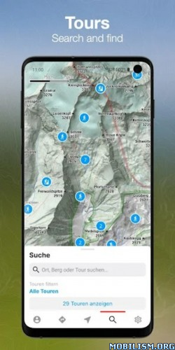
● more than 70.000 GPS-Tours
● great search functionality
● offline maps (PRO-Version)
● tool for planning your personal tours
● connectivity for bluetooth watches or chest straps
● websync with myBergfex account
● save your favourite tours
● GPX export/import

• Use the Tours App as a activity or fitness tracker (with pulse recording function and pulse zones in pro version).
• Choose one of more than 70.000 detailed hiking tours, mountainbike tours, running courses, ski tours, cycling routes and much more – inform yourself about length, height, duration, etc. to get a detailed description with photos of the tour (if you are going to hike or ride a selected tour you can use our way-leaving-function to get a warning if you once missed the right way).
• Download your maps offline on your smartphone (PRO Version) so you will not need a mobile or internet connection for navigation any more.
• Plan your personal tour from any start point to your preferred top of the mountain (this is also possible with different waypoints – in PRO Version).
• All your activities and tours-favourites are synced with your (optional) myBergfex account and you will have a backup and synced tours across all your devices.
• With the favourite functionality you have easy access to your most liked tours.

PRO-Features:
You can use all PRO-Features for one week for free!
● detailed topographical maps for Europe (with higher zoom levels)
● slope steepness overlay (to display the steepness >30°,35°,40°,45°)
● ÖK50 (detailed Austrian Mountain Map)
● offline maps (for navigation with no mobile or internet connection)
● sat-view overlay function (with additional information in the maps)
● routing function with waypoints
● pulse measurement with zones
● no advertising in PRO-Version

The Bergfex Tours App is your perfect partner for all your outdoor activities (Mountain Biking, Running, Cycling, Climbing, Nordic Walking, Ski Tours, Fitness and much more).

Note: Continued use of GPS running in the background can dramatically decrease battery life.

Terms and Conditions: http://www.bergfex.at/agb/
Privacy Policy: http://www.bergfex.at/datenschutz/

What’s New:
– Add activities from friends to my own activities
– Tour text and description can be automatically translated into the user’s language (PRO)
– New routing profile: Bicycle. Bicycle paths are preferred here. Small detours are also accepted. Ideal for easy bike tours.
– Stability and usability improvements

This app has no advertisements

More Info:
https://play.google.com/store/apps/details?id=com.bergfex.tour

Download Instructions:
https://ouo.io/zbmSNg

Mirror:
https://ouo.io/4b314Y.

Download Sygic Travel Maps Trip Planner v5.17.0 [Premium] [Mod Extra]

Sygic Travel Maps Trip Planner v5.17.0 [Premium] [Mod Extra]
Requirements: 5.0+
Overview: Discover things to do anywhere you go and build a personal travel guide for your trip. Sygic Travel Maps combine detailed offline maps with information from Sygic Travel editors, Wikipedia and other sources to create an ultimate app for every traveler.

ImageImage

20 MILLION PLACES
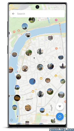
Sights, museums, parks, cafés, restaurants, hotels, beaches, waterfalls, caves or even bird observatories. Whether you’re a tourist up to sightseeing, out on a shopping trip or a romantic weekend getaway, we’ve got you covered.

PHOTOS, DESCRIPTIONS, WIKIPEDIA
Popular places come with descriptions, photos, opening hours, admission fees, links and additional data written by professional travel editors or sourced from Wikipedia and other databases.

360° VIDEOS – NEW!
Take a look around top sights in exclusive 360° videos. Over 500 professional videos from Prague, Barcelona, Valencia, Madrid, Granada, Seville, Marrakech, Gran Canaria, Porto, Lisbon, Athens, Istanbul, Cairo, Tel Aviv, Jerusalem, Betlehem and Vienna. 360° videos also support Cardboard.

MAPS DESIGNED FOR TRAVELERS
Detailed maps based on OpenStreetMap.org data adjusted for walking and exploring your destination. Built-in search and GPS-based walking directions and tight integration with the Sygic GPS Navigation.

WORLDWIDE OFFLINE MAPS
Buy Sygic Travel Premium to use the app without any internet connection, including unlimited offline maps download and walking navigation.

ADVANCED TRIP PLANNER
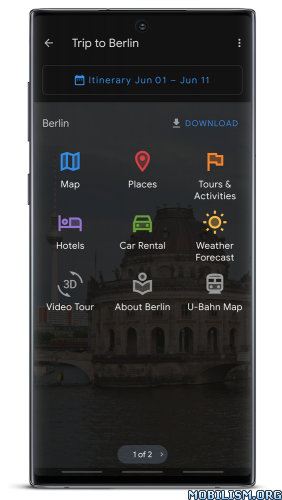
Build a complete day-to-day itinerary for your trip with an easy-to-use trip planner. See estimated travel times and walking distances and keep realistic plans. Invite your friends to collaborate on your trips.

POWERFUL SEARCH AND FILTERS
Find any place by name or address. Use filters to show attractions, museums, shopping malls, restaurants, bars down to art galleries featuring Van Gogh paintings.

TOURS AND ACTIVITES
Find the best sightseeing tours, cruises, or even local cuisine cooking classes. Buy skip-the-line tickets to top attractions straight from the app.

ACCOMMODATION
Find a hotel, hostel, apartment or b&b. Add it to your trip and see it in your daily itinerary including travel times. Book your accommodation with booking.com straight from the app.

FODOR’S TRAVEL GUIDES
Buy Sygic Travel Premium and read insightful reviews and city guides from Fodor’s and find hidden gems in your destination. City guides are available (also offline) in 50 destinations including London, Paris, New York City, Rome, Barcelona, San Francisco, Las Vegas, …

USE ON ALL DEVICES
Your trips will sync automatically between all your devices and our web planner available at https://travel.sygic.com

GET IN TOUCH WITH US
Check out our online travel maps at https://travel.sygic.com
Follow us on Twitter: https://twitter.com/SygicTravel
Like us on Facebook: https://www.facebook.com/SygicTravel/
Contact our support team: team@travel.sygic.com

What’s New:
Android 14 compatibility. Fix for walking navigation crash. Fixes and maintenance.

Do you enjoy Sygic Travel? Please help others discover it. Rating it in Google Play means a lot. Your feedback is also much appreciated. Thanks!

Mod Info:
  • Premium Subscription / Paid features unlocked;
  • Disabled / Removed unwanted Permissions + Receivers + Providers + Services;
  • Optimized and zipaligned graphics and cleaned resources for fast load;
  • Google Play Store install package check disabled;
  • Debug code removed;
  • Remove default .source tags name of the corresponding java files;
  • Analytics / Crashlytics / Firebase disabled;
  • AOSP compatible;
  • Languages: Full Multi Languages;
  • CPUs: armeabi-v7a, arm64-v8a, x86, x86_x64;
  • Screen DPIs: 120dpi, 160dpi, 240dpi, 320dpi, 480dpi, 640dpi;
  • Original package signature changed;
  • Release by Balatan.


This app has no advertisements

More Info:
https://play.google.com/store/apps/details?id=com.tripomatic

Download Instructions:
https://ouo.io/cUBCAR0

Mirrors:
https://ouo.io/xcf9rA
https://ouo.io/ss5nHd
https://ouo.io/kWdQkv
https://ouo.io/3Ia6z7
https://ouo.io/QWMcjFm
https://ouo.io/vMcF4a.