Download Waze – GPS, Maps, Traffic Alerts v4.84.90.901 Beta [Chuppito Mod]

Waze – GPS, Maps, Traffic Alerts v4.84.90.901 Beta [Chuppito Mod]
Requirements: 5.0 and up
Overview: Waze is the world’s largest community-based traffic and navigation app. Join drivers in your area who share real-time traffic & road info to save time, gas money, and improve daily commuting for all.

Image

Just by driving with Waze open, you’re already contributing tons of real-time traffic information to your local community. You can also actively report accidents, police traps and other hazards you see on the road. Get road alerts along your route and find the cheapest gas prices around you shared by the community. Plus, you can add friends, send locations or keep others posted on your arrival time.

– Live routing based on community driven, real-time traffic & road info
– Community reported alerts including accidents, hazards, police traps, road closures, and more
– Turn-by-turn voice guided navigation
– Live maps, consistently edited and updated by Waze community map editors
– Automatic rerouting as conditions change on the road
– Send your ETA & real-time drive to update those you’re meeting
– Learns your frequent destinations, commuting hours, and preferred routes
– Find the cheapest gas station on your route
– Add information on local places and businesses
– Add Facebook friends and sync Contacts
– See friends’ ETA when driving to the same destination
– One tap navigation to Facebook & Calendar events
– Earn points as you contribute road info and climb the ranks in your community

Waze is all about contributing to and benefiting from the common good, so hop on board and get involved!

Note: Continued use of GPS running in the background can dramatically decrease battery life. Waze will automatically shut down if you run it in the background and haven’t driven for a while.

Learn more about the Waze privacy policy, including what information is accessed and how it is used. With Waze, you have full control over your privacy settings. _http://www.waze.com/legal/privacy/

MOD features:
Decensored Waze version with the following improvements compared to the official version:
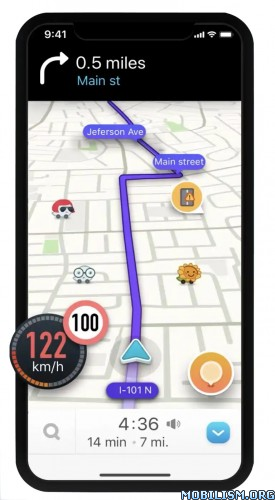
– display of the exact location of fixed or mobile speed cameras.
– enlarged speed limit sign for more readability
– Radar sound alert whatever the speed (only in case of speeding with the official version)
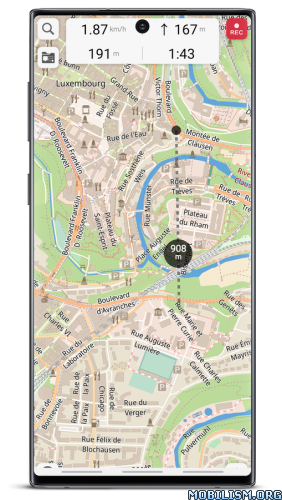
– personalized card skin with black background to save battery and improve readability
– Choice of new voices compared to the official version
– Vanessa (unmodified),
– Morgan (Cars voice is pretty cool), if you prefer Morgan’s real voice, delete the folder in waze / sound / french
– Svenska (French voice, sound boosted),
– Srpski (star wars voice the 1st voice after the English voices).
– transparent gray signal button (instead of a solid orange circle in the official version) for more map readability and to avoid the "burn" effect on the AMOLED screen
– possibility to report bad or no limitation by clicking on the speedometer then choose "report" (option absent in official version)
– announcement distance of the modified controls compared to the official version:
– highway at 1500 m
– Fast lanes at 1200 m
– Roads at 1000 m

NB; distance configurable in the "Preferences" file by adjusting these 2 lines:
Alerts.Alert Distanc_: 1000
Alerts.Police Alert Distac_: 1000

Speed ​​camera warnings have been officially banned in France since January 2012, their use is punishable by a fine of 1,500 euros and a withdrawal of 6 points on the driving license.

By installing this version, you remain responsible for its use.
Namely in France according to the law still in force to this day: The police do not have the right to search your smartphone.

What’s New:
New Beta release v.4.84.90.901. Please visit Centercode for full release notes and to submit your feedback.

Added:
Improvements in search

Fixed:
Fixes for drives not appearing in WME
Favorites won’t stay sorted after app update
Performance issues when a detour is shown
Error message when submitting a report with voice
Error message when trying to connect to Spotify
Compass hidden in landscape
Map rendering fixes to improve app stability

This app has banner and credit advertisements

More Info:
https://play.google.com/store/apps/details?id=com.waze&hl=en

Download Instructions:
https://ouo.io/Xql6bL0

Mirrors:
https://rapidgator.net/file/79e3fa2bf01 … e.apk.html
https://ouo.io/EZNx3Q

Download Locus Map 4 Outdoor Navigation v4.11.0 [Silver]

Locus Map 4 Outdoor Navigation v4.11.0 [Silver]
Requirements: 5.0 and up
Overview: Create, plan, edit, record, save or share your trips, keep the memories, track your performance, and much more. Locus Map is designed for hiking, mountain biking, cycling, running, geocaching, cross-country skiing, and other outdoor activities.

Image Image Image Image

More fun(ctions) for your adventures! Multifunctional navigation app with offline maps for a fully enjoyable outdoor experience.

Create, plan, edit, record, save or share your trips, keep the memories, track your performance, and much more. Locus Map is designed for hiking, mountain biking, cycling, running, geocaching, cross-country skiing, and other outdoor activities.

Fully customizable and flexible, offering a wide range of cool functions running above a variety of maps of the whole world.

Plan, record and manage your activities:

• plan routes along hiking trails, bike trails, or in an open terrain
• record tracks with all useful stats – distance, speed, pace, height gain, calorie burn, and other
• import and export the routes in various formats (GPX, KMZ, TCX…)
• share your tracks to Strava, Runkeeper, or Google Earth
• create your private database of interesting or favorite places
• browse your geotagged photos on the map
• import and export points of interest in various formats

Navigate and guide offline:
• turn-by-turn voice instructions or sound signals
• out-of route alert
• navigation and guidance along routes imported from elsewhere
• beeline guidance in an open terrain

Hunt for geocaches:
• download caches for offline play via G4L add-on
• navigate caches above the map or using the compass, log them online or offline
• use graphic and calculation tools
• manage your logs and drafts
• get alerted of an upcoming geocache

Customize your app:
• configure its main menu according to your actual needs
• set the main screen – function panels, right/left-hand control, light/dark mode…
• set coords system, units, dashboards and screens
• enjoy the app’s flexibility with the configuration presets

Use maps from our wide selection:

LoMaps – offline maps of the whole world
• switchable to hiking/biking map, winter or city map. Download 3 of them for FREE.

Outdoor maps by the world’s best cartographic publishers
• USA&Canada – USGS classic/satellite, AccuTerra trail maps, BackRoad Map Books,
• Europe – Ordnance Survey (UK), Kompass, Outdooractive, Freytag&Berndt (Germany, Austria, Italy), IGN (France, Belgium), CNIG (Spain), Lantmäteriet (Sweden), Kortforsyningen (Denmark), PZS (Slovenia), Compass (Poland), Swisstopo (Switzerland), SHOCart (Czechia, Slovakia) and many others…

• add external maps in SQLite, TAR, MBT, GEMF, Orux or RMA formats

Get even more with the Premium subscription

Go fully offline
• enjoy offline LoMaps of the whole world including updates without extra charges
• search offline addresses and LoPoints
• navigate and plan routes with the built-in offline router
• display elevation of any place on Earth without an internet connection

Keep synced
• use your tracks, routes, and points synced across multiple devices including web portal

Go web
• plan routes on a big PC screen, sync them with your mobile devices
• browse, view and manage your routes and tracks in a web library

Go live
• share your location in real-time with your family or friends in your own private groups

Sport packet
• connect the app with BT/ANT+ sensors
• work out with audio coach
• monitor your rides on a dashboard with handsfree screen control

Map tools
• calibrate map images
• overlay two various maps
• set map offset

And enjoy all other Premium features of the app
• 24/7 weather forecast on any place on Earth
• parking assistant
• no ads and LoCoin bonuses

App uses the Device Administrator permission

What’s New:
*** Locus Map 4.11 ***
– new "Locus account" screen with manage/edit options
– option to add user photos to the public online LoPoints
– and many more

This app has no advertisements

More Info:
https://play.google.com/store/apps/details?id=menion.android.locus&hl=en

Download Instructions: credit Timozhai
https://ouo.io/Ehw13h

Mirrors:
https://rapidgator.net/file/ed3f81b62f3 … r.apk.html
https://ouo.io/yysXmo

Download When to Fish v3.2.0 [Premium]

When to Fish v3.2.0 [Premium]
Requirements: 4.4+
Overview: When to Fish is a practical advisor for every fisherman, who knows, that the catch isn’t just a question of luck.

Image Image

When to Fish is a practical advisor for every fisherman, who knows, that the catch isn’t just a question of luck. Based on location, weather, season and other data, predicted activity of the freshwater fish and hunting conditions are calculated.

Features:
– Forecast for hunt conditions: carp, grass carp, zander, pike, catfish, bass, perch, bream, crappie, barbel, tench
– Forecast for general fish activity
– Forecast for weather, pressure, wind etc
– Current moon phase

This is only forecast. Forecast in application is not a garancy of catch
– only freshwater fishing

With the Premium Membership you will get half year’s subscription for:
– Hourly forecasts for today and tomorrow
– Daily forecasts for upcoming 5 days
Forecasts contain fishing conditions and fish activity

What’s New:
Error fixes, Application redesign, Chart in barometer, Portuguese

This app has no advertisements

More Info:
https://play.google.com/store/apps/details?id=com.miros.whentofish

Download Instructions:
https://ouo.io/Vjlk3h

Mirror:
https://ouo.io/C4V781

Download Guru Maps Pro v5.0.6 [Patched] [Mod Extra]

Guru Maps Pro v5.0.6 [Patched] [Mod Extra]
Requirements: 4.1+
Overview: Detailed and easy to use offline maps. We have millions POI on our maps. Record your GPS tracks and bookmark your favorite locations.

Image

OFFLINE MAPS
• Amazingly detailed maps of all countries of the world.
• Based on open data from OpenStreetMap project. OSM is an open-source alternative to Mapquest, Google Maps and Waze.
• Updated monthly with improved data.

BOOKMARKS
• Save favorite places on your map.
• Choose from lots of icons to assign to bookmarks.

GPS TRACKS
• Record your trips even when app is in background.
• Monitor your real-time speed, distance and time travelled, as well as altitude right on the map during the trip.
• Choose from 7 solid track colors or altitude and speed gradients.

IMPORT AND EXPORT
• It’s easy to export your tracks, bookmarks or whole travel collection as KML or GPX file.
• User itinerary is organized to collections for easy access.

SMALL FEATURES
• MBTiles and sqlitedb offline raster maps support.
• One finger zooming.
• Trip computer with speed and altitude.
• Tracking mode.
• Coordinates and scale.
• Visible object set could be customized.
• 11 different map languages is supported.
• Map labels size could be changed. Large labels on maps is extremely useful while driving.

MAPS
Going on vacation? Don’t forget to download an offline map with you. Rome, Italy? Just 16Mb. Paris, France? Just 67Mb. Barcelona, Spain? 197Mb. Amsterdam, Netherlands? 261Mb. London, UK? 283Mb. New York, Chicago, Florida, Las Vegas, Nevada, Seattle, San Francisco, California, USA? 500Mb in total.

Continued use of GPS running in the background can dramatically decrease battery life.

What’s New:
Added automatic backups. Fixed possible causes of data loss.

The User Cabinet appeared. With a single account, it became more convenient to enable data synchronization on devices from different manufacturers.
Read more information about this update on our social networks.

Mod Info:

  • No root or Lucky Patcher or Google Play Modded required;
  • Disabled / Removed unwanted Permissions + Receivers + Providers + Services;
  • Optimized and zipaligned graphics and cleaned resources for fast load;
  • Google Play Store install package check disabled;
  • Debug code removed;
  • Remove default .source tags name of the corresponding java files;
  • Analytics / Crashlytics / Firebase disabled;
  • AOSP compatible mode;
  • Languages: Full Multi Languages;
  • CPUs: armeabi-v7a, arm64-v8a;
  • Screen DPIs: 120dpi, 160dpi, 240dpi, 320dpi, 480dpi, 640dpi;
  • Original package signature changed;
  • Release by Balatan.

This app has no advertisements

More Info:
https://play.google.com/store/apps/details?id=com.bodunov.GalileoPro

Download Instructions:
armeabi-v7a:
https://ouo.io/QAGJJl

Mirrors:
https://ouo.io/t9nq0j
https://ouo.io/3XAeKA
https://ouo.io/fdeHnI
https://ouo.io/XpxG17
https://ouo.io/UWI7gB
https://ouo.io/Fc9GPYQ

arm64-v8a:
https://ouo.io/TylS1Gn

Mirrors:
https://ouo.io/AMUiGK
https://ouo.io/WKc3gq
https://ouo.io/IPu5PP
https://ouo.io/9t3UFa
https://ouo.io/j8Vqyj
https://ouo.io/D9WozeL

Download Waze – GPS, Maps, Traffic Alerts & Live Navigation v4.85.0.6 Beta

Waze – GPS, Maps, Traffic Alerts & Live Navigation v4.85.0.6 Beta
Requirements: 5.0 and up
Overview: Waze is the world’s largest community-based traffic and navigation app. Join drivers in your area who share real-time traffic & road info to save time, gas money, and improve daily commuting for all.

Image

Just by driving with Waze open, you’re already contributing tons of real-time traffic information to your local community. You can also actively report accidents, police traps and other hazards you see on the road. Get road alerts along your route and find the cheapest gas prices around you shared by the community. Plus, you can add friends, send locations or keep others posted on your arrival time.

– Live routing based on community driven, real-time traffic & road info
– Community reported alerts including accidents, hazards, police traps, road closures, and more
– Turn-by-turn voice guided navigation
– Live maps, consistently edited and updated by Waze community map editors
– Automatic rerouting as conditions change on the road
– Send your ETA & real-time drive to update those you’re meeting
– Learns your frequent destinations, commuting hours, and preferred routes
– Find the cheapest gas station on your route
– Add information on local places and businesses
– Add Facebook friends and sync Contacts
– See friends’ ETA when driving to the same destination
– One tap navigation to Facebook & Calendar events
– Earn points as you contribute road info and climb the ranks in your community

Waze is all about contributing to and benefiting from the common good, so hop on board and get involved!

Note: Continued use of GPS running in the background can dramatically decrease battery life. Waze will automatically shut down if you run it in the background and haven’t driven for a while.

Learn more about the Waze privacy policy, including what information is accessed and how it is used. With Waze, you have full control over your privacy settings. _http://www.waze.com/legal/privacy/

★ Untouched apk with Original Hash Signature
★ Certificate MD5 digest: 973cbf4c6cc7c602486328f140c781ea
★ No changes were applied
➡ Languages: Full Multi Languages
➡ CPU architectures: arm64-v8a, armeabi-v7a
➡ Screen DPIs: 120dpi, 160dpi, 240dpi, 320dpi, 480dpi, 640dpi

What’s New:
New Beta release v.4.85.0.6. Please visit Centercode for full release notes and to submit your feedback.

Fixed:
Bug fixes and improvements

This app has banner advertisements

More Info:
https://play.google.com/store/apps/details?id=com.waze&hl=en

Download Instructions:
https://ouo.io/k19ujs

Mirrors:
https://rapidgator.net/file/8cf0f2f9aca … 4.apk.html
https://ouo.io/UFZmd3