Download Geotag Photos Pro 2 v1.5.5 [Unlocked]

Geotag Photos Pro 2 v1.5.5 [Unlocked]
Requirements: 4.0 and up
Overview: Geotag Photos Pro is professional geotagging solution – all you need to geotag photos taken by your EXTERNAL camera (DSLR, mirrorless or compact one).

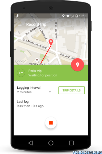
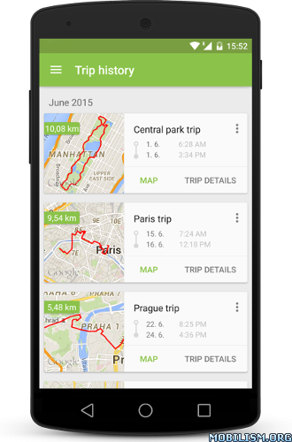
ImageImage

It supports JPG & RAW photos and its data can be used also with Lightroom, Aperture, Picasa and other photo apps that supports geotagged photos.

Try 3 trips for FREE and then unlock the full app for a one time fee.

Geotag Photos Pro is praised by industry experts
– Geotagging App of the Year by Macworld
– Repeatedly recommended by leading Adobe Lightroom professionals
– Recommended in many great books such as Lightroom 4 UnMasked, Lightroom 4 the missing FAQ, Lightroom 4 Roadmap for photographers
– Praised by leading photography magazines and websites all over the world (Techradar, Ephotozine, Fotomaf, Xatakafoto, Lightroom Secrets, Digital-Fotografie, Pixelmania.nl, Photoplus…)

Best facts about Geotag Photos Pro
– Complete solution – mobile app records your position while you’re taking great photos and a desktop app geotags your images using recorded data.
– Flawless Lightroom Compatibility – GPX files from the app work flawlessly inside Lightroom’s Map module for geotagging
– Dropbox and Google Drive support – automatically export all your trips as GPX files
– Smart watch app – dedicated app for Android Wear and Pebble to control app from your wrist ! Automatic trip upload – the app automatically sync all your trips ( you can switch to manual uploads in settings)
– Battery usage optimized for whole day of geotagging
– Choose the logging interval and accuracy for whatever you need
– Organized trips history
– Statistics of your trips
– Export to GPX

FREE desktop geotagging app
Adds GPS location to your your JPG or RAW photos quickly and easily! Works both online and offline and there are version for any operating system – Mac OS X, Windows and even Linux

Supported image formats: jpg, nef, cr2, crw, dcr, ciff, erf, orf, k25, kdc, mef, mrw, nrw, pef, raf, tif, tiff, raw, arw, rw2, srf, sr2, srw, x3f, dng

Visit our website for more info http://www.geotagphotos.net

What’s New
v1.5.5
– many fixes under the hood
v1.5.3
– fix issue with Android Wear
v1.5.0
– NEW map types (satellite, hybrid and terrain)
– NEW Trip name advisor (based on your location)
– NEW languages (German, Italian, Spanish)
– many fixes and design improvements

● Paid features Unlocked

This app has no advertisements

More Info:

https://play.google.com/store/apps/details?id=com.tappytaps.android.geotagphotospro2

Download Instructions:
https://douploads.com/dks3h8kr35gg

Mirrors:
https://dropapk.com/lfu61iyikqnj
https://userscloud.com/rr4l308rzm2t
https://uploadocean.com/4hi33mnt9ct2
Download FLY is FUN Aviation Navigation Unlimited v19.81 [Unlocked] APK for Android +4.0.3


Requirements: 4.0.3+

Description:

FLY is FUN – 30 days trial

FLY is FUN is a moving map for aviation and pilots providing ILS and GPS approach, VOR, NDB, DME, Marker beacons, RNAV navigation and Marker beacons warnings, without ILS/VOR/NDB/RNAV equipment on board.

“FLY is FUN” is a complete application, without any restriction, if used with “FLY is FUN Unlocker”.
Without “FLY is FUN Unlocker”, all functionalities are accessible for evaluation. This allows news user discovering them, but each 10 minutes, application need to be restarted.

FLY is FUN allows:
– Creating Flight Plan and export it to Excel
– Creating Flight log and export it to Excel
– Displaying route, bearing, trace on moving map;
– Visualizing airspace;
– Creating and modifying routes with “drag and drop”, "rubber band" , or with the database;
– Importing, exporting routes, waypoints, RWY (Garmin .gpx, .kml, txt);
– Performing route planning, evaluating distance, time and fuel consumption (depending on wind and aircraft characteristics);
– Recording the flight and playing it back with Google Earth;
– Calculating Sunset / Sunrise;
– Getting weather forecast along the route;
– Getting warnings, alarms and message before entering controlled or special use airspaces, approaching waypoints or specific points;
– Creating or importing airspace (Google Earth or Open air files);
– Getting dynamic terrain map (colors depending of elevation above ground level),
– Displaying more than 80 values

All main screens (4 portrait and 4 landscape screens) could easily be customized. Pilot can choose information he wish to get in each button:
– Altitude GPS or barometric, over see, over ground, correction;
– Ground speed;
– Bearing;
– Vertical speed;
– Distance to point , distance to destination;
– Estimated time to next point, estimated time to destination;
– Time since departure;
– Stop watch;
– DME, ACC, GS, ALT, TRK, BRG, AGL, ELE, CAL, VAR, UTC, LOG, HDG, CRS, ETA, ET, ETE, LT, MGS, GAL, SR, SS, XTK, PRE, QNH, VSI, RRD, SW1, SW2, RRD, DTA, DAL;

Information displayed could be customized too depending of users preferences (VFR, IFR, IFR and VFR) and of zoom level. The more you zoom IN, the more detail, information, waypoints,.. you see

Logbook
The integrated logbook, allows recording:
– Duration since departure time
– Departure and arrival time
– Departure and arrival airport
– Flight track (it is possible to export it as .kml or .gpx and to replay it)
– Used aircraft
– Pilot(s) and copilots in charge
– Distance, average speed, maximum speed

Charts
Pilots could select the most appropriate charts: free open source charts as well as commercial charts as ICAO, Cartabossy, SkyVector… even FAA sectional and terminal charts…
Free charts could be imported directly via the application store. Other charts could be created and imported by the pilot itself or made on request available as commercial service.

VACs and PDF files
User can easily attached PDF files to airport or ULM fields, and consult them during the fly.

Usage of external GPS connected via Bluetooth is possible

The free World navigation and airspace database is updated following AIRAC cycle.

User guide: http://funair.cz/forum/viewforum.php?f=11

If you have any suggestion to improve this application or you find some bug please visit www.flyisfun.com

Use this application for VFR FLYING ONLY!!! We are not responsible for any use of this application.

Tags:
VOR, ILS, GPS, LOC, FIX, navigation, ULM, airplane, aviation, avionics, helicopter, gyropter, LSA, ultra light, glass cockpit, aircraft, plane, IFR, VFR, terrain alert, compass, altimeter, HSI, PFD, navigation aid database, altimeter, logger, declination, simulator, moving map, sunrise sunset calculator, RNAV, GPS ILS VOR glasscockpit, pressure, barometric sensor, baro altitude, VSI, airspaces, GPWS, METAR, TAF, radar, ADS-B, density altitude, MGRS, ICAO, FAA sectional charts, FAA terminal charts, Cartabossy, VAC

Download Links:

Download via DropApk
Mirrors:
Download via UsersCloud

Download FLY is FUN Aviation Navigation Unlimited v19.43 [Unlocked] APK for Android +4.0.3


Requirements: 4.0.3+

Description:

FLY is FUN – 30 days trial

FLY is FUN is a moving map for aviation and pilots providing ILS and GPS approach, VOR, NDB, DME, Marker beacons, RNAV navigation and Marker beacons warnings, without ILS/VOR/NDB/RNAV equipment on board.

“FLY is FUN” is a complete application, without any restriction, if used with “FLY is FUN Unlocker”.
Without “FLY is FUN Unlocker”, all functionalities are accessible for evaluation. This allows news user discovering them, but each 10 minutes, application need to be restarted.

FLY is FUN allows:
– Displaying route, bearing, trace on moving map;
– Visualizing airspace;
– Creating and modifying routes with “drag and drop”, "rubber band" , or with the database;
– Importing, exporting routes, waypoints, RWY (Garmin .gpx, .kml, txt);
– Performing route planning, evaluating distance, time and fuel consumption (depending on wind and aircraft characteristics);
– Recording the flight and playing it back with Google Earth;
– Calculating Sunset / Sunrise;
– Getting weather forecast along the route;
– Getting warnings, alarms and message before entering controlled or special use airspaces, approaching waypoints or specific points;
– Creating or importing airspace (Google Earth or Open air files);
– Getting dynamic terrain map (colors depending of elevation above ground level),
– Displaying more than 80 values

All main screens (4 portrait and 4 landscape screens) could easily be customized. Pilot can choose information he wish to get in each button:
– Altitude GPS or barometric, over see, over ground, correction;
– Ground speed;
– Bearing;
– Vertical speed;
– Distance to point , distance to destination;
– Estimated time to next point, estimated time to destination;
– Time since departure;
– Stop watch;
– DME, ACC, GS, ALT, TRK, BRG, AGL, ELE, CAL, VAR, UTC, LOG, HDG, CRS, ETA, ET, ETE, LT, MGS, GAL, SR, SS, XTK, PRE, QNH, VSI, RRD, SW1, SW2, RRD, DTA, DAL;

Information displayed could be customized too depending of users preferences (VFR, IFR, IFR and VFR) and of zoom level. The more you zoom IN, the more detail, information, waypoints,.. you see

Logbook
The integrated logbook, allows recording:
– Duration since departure time
– Departure and arrival time
– Departure and arrival airport
– Flight track (it is possible to export it as .kml or .gpx and to replay it)
– Used aircraft
– Pilot(s) and copilots in charge
– Distance, average speed, maximum speed

Charts
Pilots could select the most appropriate charts: free open source charts as well as commercial charts as ICAO, Cartabossy, SkyVector… even FAA sectional and terminal charts…
Free charts could be imported directly via the application store. Other charts could be created and imported by the pilot itself or made on request available as commercial service.

VACs and PDF files
User can easily attached PDF files to airport or ULM fields, and consult them during the fly.

Usage of external GPS connected via Bluetooth is possible

The free World navigation and airspace database is updated following AIRAC cycle.

User guide: http://funair.cz/forum/viewforum.php?f=11

If you have any suggestion to improve this application or you find some bug please visit www.flyisfun.com

Use this application for VFR FLYING ONLY!!! We are not responsible for any use of this application.

Tags:
VOR, ILS, GPS, LOC, FIX, navigation, ULM, airplane, aviation, avionics, helicopter, gyropter, LSA, ultra light, glass cockpit, aircraft, plane, IFR, VFR, terrain alert, compass, altimeter, HSI, PFD, navigation aid database, altimeter, logger, declination, simulator, moving map, sunrise sunset calculator, RNAV, GPS ILS VOR glasscockpit, pressure, barometric sensor, baro altitude, VSI, airspaces, GPWS, METAR, TAF, radar, ADS-B, density altitude, MGRS, ICAO, FAA sectional charts, FAA terminal charts, Cartabossy, VAC

Download Links:

Download via DropApk
Mirrors:
Download via Uploads