Download GPS Emulator v2.75 [Mod]

GPS Emulator v2.75 [Mod]
Requirements: 5.0 and up
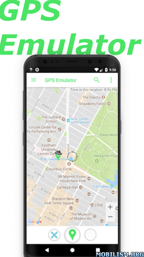
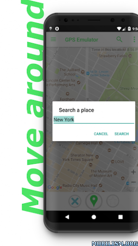
Overview: Move your phone to any place in the world with this app! It sets up a fake GPS location so other apps in your phone believes you are there

Image Image

With this fake gps you can change your location and altitude. You can also tweak the accuracy and get the current time of the fake position.

Three map types are available: normal satellite and terrain. Fake GPS coordinates injection can be enabled/disabled for Google Play Location Services as well.

Attention: this app was not designed to cheat on games it’s only for developer testing purposes.

Mod Info:
Paid features unlocked.
Unnecessary receivers/activities/alarms/permissions/metadata etc removed from manifest


What’s New:
Several improvements.

This app has no advertisements

More Info:
https://play.google.com/store/apps/details?id=com.rosteam.gpsemulator

Download Instructions:
https://ouo.io/SEE9VK

Mirror:
https://ouo.io/kcW4L8

Trouble downloading? Read This.

Download Digital Compass v10.2 [Premium]

Digital Compass v10.2 [Premium]
Requirements: 4.4+
Overview: Introducing the ultimate precise compass app for Android – your reliable and accurate wayfinding companion.

Image

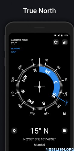
Digital compass is an accurate smart compass app and a great tool for your outdoor activities to keep you aware of your current direction. This compass app allows you to easily identify the direction (bearing, azimuth, degree) you currently facing. Discover true north and enhance your wayfinding abilities with our advanced GPS compass app. Beside, It is useful for muslim prayer to find the Qibla(Kiblat). There is still many way you can benefit from just this advanced GPS compass pre-installed in your device.

Key feature:
– It is a free compass
– Display highly precise direction and orientation
– Display the current coordinate and location(longitude, latitude, address)
– Display the altitude
– Display magnetic field strength(EMF)
– Show the slope angel(Slope Level)
– Show the current accuracy state
– Show both magnetic north and geographic north(true north)
– Show all available sensor status on this device
– Add a direction pointer marker

Caution:
The accuracy of the GPS compass will get interfere when the device is near any other magnetic interference, be sure to stay away from magnetic things/objects such as another electronic device, battery, magnet, etc while using the digital compass. If the accuracy becomes unreliable, calibrate the device by simultaneously flipping and moving the phone back and front in patterns 8.

Some of the common usage of digital compass are:
– Adjust Television Antenna
– Vastu Tips
– Find Qibla compass muslim prayer for muslim prayer to find the Kiblat
– Horoscope searching
– Fengshui(Chinese)
– Outdoor activities
– Education purpose

Direction:
• N point to the North
• E point to the East
• S point to the South
• W point to the West
• NE point to North-East
• NW point to North-West
• SE point to South-East
• SW point to South-West

This digital compass build using the gyroscope, accelerator, magnetometer, gravity of the device. Make sure your device at least has the accelerator sensor and magnetometer sensor or else this smart compass might not function properly.

What are you waiting for? Navigate with precision using our accurate compass app for outdoor adventures and travel. Download our free compass app now!

What’s New:
Version 10.2
– UI/UX improvement
– New coordinate format added

This app has credit advertisements

More Info:
https://play.google.com/store/apps/details?id=com.ktwapps.digitalcompass&hl=en

Download Instructions:
https://ouo.io/bDGvbu

Mirror:
https://ouo.io/GvZemH4
https://ouo.io/w3P9LFQ

Trouble downloading? Read This.

Download bergfex Hiking & Tracking v4.8.1 [Pro]

bergfex Hiking & Tracking v4.8.1 [Pro]
Requirements: 7.0+
Overview: The perfect ALL-IN-ONE tool for all your outdoor activities. Use it for Hiking, Mountain Biking, Running, Cycling, Climbing, Nordic walking, Ski Tours, Fitness and much more.

Image

Outdoor Tracking & Tours App
The perfect ALL-IN-ONE tool for all your outdoor activities. Use it for Hiking, Mountain Biking, Running, Cycling, Climbing, Nordic walking, Ski Tours, Fitness and much more.
Your Tool for tracking and planing your tours:
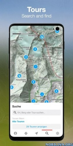
● detailed topographical maps for Europe
● more than 70.000 GPS-Tours
● great search functionality
● offline maps (PRO-Version)
● tool for planning your personal tours
● connectivity for bluetooth watches or chest straps
● websync with myBergfex account
● save your favourite tours
● GPX export/import

• Use the Tours App as a activity or fitness tracker (with pulse recording function and pulse zones in pro version).
• Choose one of more than 70.000 detailed hiking tours, mountainbike tours, running courses, ski tours, cycling routes and much more – inform yourself about length, height, duration, etc. to get a detailed description with photos of the tour (if you are going to hike or ride a selected tour you can use our way-leaving-function to get a warning if you once missed the right way).
• Download your maps offline on your smartphone (PRO Version) so you will not need a mobile or internet connection for navigation any more.
• Plan your personal tour from any start point to your preferred top of the mountain (this is also possible with different waypoints – in PRO Version).
• All your activities and tours-favourites are synced with your (optional) myBergfex account and you will have a backup and synced tours across all your devices.
• With the favourite functionality you have easy access to your most liked tours.

PRO-Features:
You can use all PRO-Features for one week for free!
● detailed topographical maps for Europe (with higher zoom levels)
● slope steepness overlay (to display the steepness >30°,35°,40°,45°)
● ÖK50 (detailed Austrian Mountain Map)
● offline maps (for navigation with no mobile or internet connection)
● sat-view overlay function (with additional information in the maps)
● routing function with waypoints
● pulse measurement with zones
● no advertising in PRO-Version

The Bergfex Tours App is your perfect partner for all your outdoor activities (Mountain Biking, Running, Cycling, Climbing, Nordic Walking, Ski Tours, Fitness and much more).

Note: Continued use of GPS running in the background can dramatically decrease battery life.

Terms and Conditions: http://www.bergfex.at/agb/
Privacy Policy: http://www.bergfex.at/datenschutz/

What’s New:
– Highlights: public highlights are displayed along the route
– Tracking: elevation data can be improved by using the elevation model from bergfex (Settings -> Tracking -> Elevation model), enabled by default for devices without barometer
– Maps: preview of offline maps now matches the selected map section and type
– Other: bug fixes and general stability improvements

This app has no advertisements

More Info:
https://play.google.com/store/apps/details?id=com.bergfex.tour

Download Instructions:
https://ouo.io/KRgcwJ

Mirror:
https://ouo.io/evipFj

Trouble downloading? Read This.

Download Mgrs & Utm Map Pro v7.3 [Patched]

Mgrs & Utm Map Pro v7.3 [Patched]
Requirements: 6.0 and up
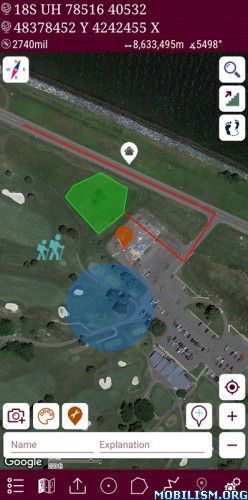
Overview: This application is GPS and coordinate systems helper. It is a complete helper for mountaineering, trekking and hiking, cross running, scouting, hunting, fishing, geocaching, off-road navigation and all other outdoor activities and sports.
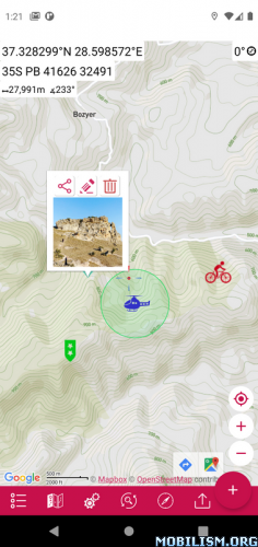
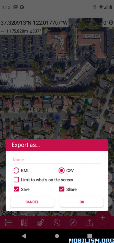
Image

Special features at pro version:

➠ More maps (Bicycle, Topographic, Neighborhood, Atlas etc.)
➠ You can see the altitude profile of your route on the chart
➠ You can search for locations by address
➠ You can create different layers for your different activities
➠ List view for markers, routes, areas and KML
➠ You can draw multiple routes and areas, and change their colors
➠ More and colorful pointer icons
➠ Name or icon display options for markers
➠ Multiple routes can be recorded with the GPS recorder
➠ And no ads

This application is GPS and coordinate systems helper.

It is a complete helper for mountaineering, trekking and hiking, cross running, scouting, hunting, fishing, geocaching, off-road navigation and all other outdoor activities and sports.

With satellite navigation systems such as GPS, GALILEO and GLONASS (GNSS) supported by your device and your sensors, you can see your most accurate position on different map layers.

Features:

* Easy and Faster
* Compass.
=> Compass on map (on the map that shows your direction)
=> Compass only (shows physical directions)
=> Angular units for compass (degrees, grad and mil)
* Follow Mode
=> The center of the map follows your location while on the move.
* You can add and removing markers.
* Distance measure. (You can add custom route and calculate total distance)
* Area measure.(You can select an area on the map and calculate the area in square meters)
* You can see the altitude of your location.
* You can find the location according to Address, Degree/Minute/Second , MGRS, UTM or Latitude/Longitude formats.
* Location (Coordinate) unit options.
=> MGRS / U.S. National Grid (USNG) (WGS84/NAD83)
=> D°M’S" (WGS84)
=> Latitude/Longitude (WGS84)
=> UTM (WGS84/NAD83)
=> SK42(Gauss Kruger)
=> British National Grid(OSNG)
=> Irish Grid Reference
=> ED50
=> ITRF
* Map type options (Road,Terrain,Satellite,Night Mode,Hybrid)
* You can share location coordinate.
* Distance unit options. (meter and feet).
* KML viewer. (Export and import KML layers).

What’s New:
* Fixed the issue of adding images to placemarks.

This app has no advertisements

More Info:
https://play.google.com/store/apps/details?id=com.zahidcataltas.mgrsutmmappro&hl=en

Download Instructions: credit maxi123444
https://ouo.io/VDSwQdP

Mirror:
https://ouo.io/Go2Rxz
https://ouo.io/dylbrL
https://ouo.io/fBzURR

Download Hawk Map Pro v2.2.1 [Patched]

Hawk Map Pro v2.2.1 [Patched]
Requirements: 6.0+
Overview: GPS and coordinate systems helper. GPS app that includes GIS, measurement and planning tools. It is a complete helper for airsoft, mountaineering, trekking and hiking, cross running, scouting, hunting, fishing, geocaching, off-road navigation and all other outdoor activities and sports.

Image Image

⭐⭐Pro Features⭐⭐
➠ List view for map markings.
➠ Adding photos to map markings.
➠ Display an altitude graph for a drawn route.
➠ Location search by address.
➠ Export the coordinates of the marked points in "CSV" format.
➠ More map options. (Topographic, cycling, etc.)
➠ Add custom map files in "mbtiles" format. (File content must be jpg or png, does not support vectors)
➠ Ability to add map url to be able to use maps of different map providers.
➠ More marker icons.
➠ Ad-free.

This app is a modern version of our "Mgrs & Utm Map" application.
GPS and coordinate systems helper especially for military personnel.

It is also a complete helper for airsoft, mountaineering, trekking and hiking, cross running, scouting, hunting, fishing, geocaching, off-road navigation and all other outdoor activities and sports.

With satellite navigation systems such as GPS, GALILEO and GLONASS (GNSS) supported by your device and your sensors, you can see your most accurate position on different map layers.

⭐⭐Features⭐⭐

➠ Coordinate Indicator, finder and converter
Format options:
– D°M’S" (WGS84)
– Latitude/Longitude (WGS84)
– UTM (WGS84/NAD83),
– MGRS / U.S. National Grid (USNG) (WGS84/NAD83)
– SK42(Gauss Kruger)
– British National Grid(BNG-OSNG)
– Irish Grid Reference
– ED50 (6°-3°)
– ITRF (6°-3°)
➠ You can make colored markings on the map.
Markers,Polygons,Polylines,Circles
➠ Area & Distance measurement
Distance unit options: m , ft , mi , yd , nmi
Area unit options: m² , ha , ft², yd², mi²
➠ Elevation information
➠ Compass
Angular unit options: Degrees ,NATO mil, Warsaw Mil, Grad
➠ Map style options: (Road,Terrain,Satellite,Night Mode,Hybrid)
➠ KML viewer. (Export and import KML layers).
➠ GPS track recorder.

What’s New:
No changelog

This app has no advertisements

More Info:
https://play.google.com/store/apps/details?id=com.zahidcataltas.hawkmappro&hl=en

Download Instructions: credit maxi123444
https://ouo.io/8r1a6P

Mirrors:
https://ouo.io/RRZvkv
https://ouo.io/IK0pF8
https://ouo.io/Dj9yDgX