Download OsmAnd+ — Maps & GPS Offline v4.9.5 [OsmAnd Live] [Mod Extra]

OsmAnd+ — Maps & GPS Offline v4.9.5 [OsmAnd Live] [Mod Extra]
Requirements: 7.0+
Overview: Osmand is opensource navigation application with raster/vector maps
ImageImage

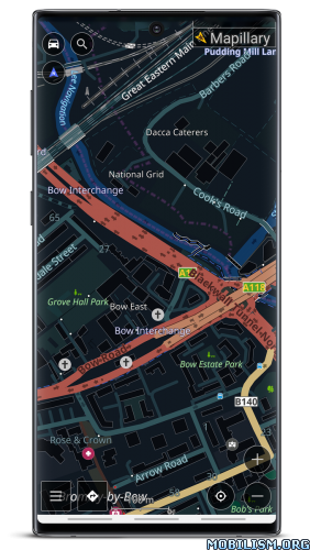
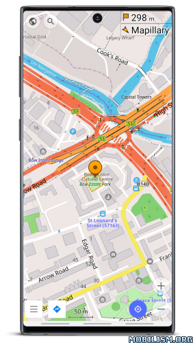
Osmand+ is an open source navigation application with access to a wide variety of global open street map data. All map data (vector or tile maps) can be stored on the phone memory card for offline usage. Osmand also offers offline and online routing functionality including voice guidance.
Osmand+ is the paid application version, by buying it you support the project, fund the development of new features, and receive the latest updates.
Some of the core features:
– Complete offline functionality (store downloaded vector or tile maps in a selectable folder)
– Compact offline vector maps for the whole world available
– Unlimited downloading of country or region maps directly from the app
– Offline Wikipedia feature (download Wikipedia POIs), great for sightseeing
– Overlay of several map layers possible, like GPX or navigation tracks, Points of Interest, favorites, contour lines, public transportation stops, additional maps with customizable transparency
– Offline search for addresses and places (POIs)
– Offline routing for short distances (experimental)
– Car, bicycle, and pedestrian modes with:
– Optional automated day/night view switching
– Optional speed-dependent map zooming
– Optional map alignment according to compass or direction of motion

What’s new
• Added a full-screen gallery viewer for Wikimedia images
• Introduced a new plugin "Vehicle Metrics" to monitor vehicle performance using the OBD-II protocol
• Added the ability to assign activities to tracks and filter them accordingly
• Implemented new quick actions for trip recording and touchscreen lock
• Introduced customizable map button appearance and a precise grid
• Added a context menu and a "Reset average speed" action to widgets
• Added new route layer "Dirt Bike trails"

Mod Info:
  • OsmAnd Live / Paid features unlocked;
  • Disabled / Removed unwanted Permissions + Receivers + Providers + Services;
  • Optimized and zipaligned graphics and cleaned resources for fast load;
  • Debug code removed;
  • Analytics disabled;
  • AOSP compatible mode;
  • Languages: Full Multi Languages;
  • CPUs: armeabi-v7a, arm64-v8a, x86, x86_64;
  • Screen DPIs: 160dpi, 240dpi, 320dpi, 480dpi, 640dpi;
  • Original package signature changed;
  • Release by Balatan.


This app has no advertisements

More Info:
https://play.google.com/store/apps/details?id=net.osmand.plus

Download Instructions:
All-in-One Universal Mod:
https://ouo.io/iFS22Kw

Mirrors:
https://ouo.io/cA7e7j
https://ouo.io/a1BKADV
https://ouo.io/mKGvWml
https://ouo.io/J3Tkab
https://ouo.io/dHjEIk

armeabi-v7a:
https://filespayout.com/uqhzcqn5djve/Os … bi-v7a.apk

Mirrors:
https://ouo.io/4yCL0P
https://ouo.io/6oQ39m
https://ouo.io/tReEbw
https://ouo.io/31BH2h5
https://ouo.io/AEB1s3

arm64-v8a:
https://ouo.io/2AECPI

Mirrors:
https://ouo.io/bLXoy9C
https://ouo.io/NESWyzb
https://ouo.io/zQ4i6rg
https://ouo.io/8POUOM
https://ouo.io/W9ZNR4a

Trouble downloading? Read This.
Download Altimeter professional v5.2 [PRO]

Altimeter professional v5.2 [PRO]
Requirements: 4.4 and up
Overview: Professional altimeter. Very accurate position and altitude detection

Image

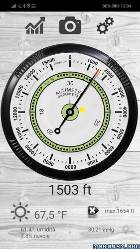
Through this Altimeter application you will be able to know the real height of where you are. Very accurate from a graphic point of view, it reproposes an analogue altimeter with digital measurement. It also stores the maximum height reached, very useful for hiking in the mountains. You can also view the quality and accuracy at any time. It uses both the GPS and the barometric sensor (for devices equipped) that can be activated by the options.
You can see the altitude in meters or feet and calibrate the altitude from the settings panel.
You will be able to record the altitude trend over time and view the relative graph, also monitoring the trend of the weather forecast based on the barometric pressure with the histogram graph.
With the function take photos, you can take personalized photographs (with the altitude and the place where you are), share them with facebook, whatsapp, email etc.
Possibility to send an SMS in case of need to a contact you have chosen with GPS coordinates and your position on the map.
Very interesting is also the use of the widget to be installed in the screen to keep the altitude under control.

Some features:
– Professional algorithm for precise altitude detection in real time
– Trend in altitude time for excursions and walks
– SMS Alert system in case of need by sending the position to a chosen contact
– Accurate and real-time weather forecasts
– Function takes photos with superimposed data
– Widget

What’s New:
– Improved permission management
– Increased altitude acquisition speed
– Reporting of settings issues with autofix
– Improved route management with real-time map and altitude variation

☆PRO features unlocked
☆Ads Layout removed/Ad activity Removed
☆Optimized Graphics/Zipaligned
☆Remove default .source name of java files;
☆Cleaned Package for fast load
☆Debug Info Removed


This app has no advertisements

More Info:
https://play.google.com/store/apps/details?id=com.ffz.altimetrofree

Download Instructions:
https://ouo.io/qLM11j

mirror:
https://ouo.io/QCmbK6
https://ouo.io/g8YVGU
https://ouo.io/RQ59Wk

Download Map Coordinates v5.7.0 [Pro] [Mod Extra]

Map Coordinates v5.7.0 [Pro] [Mod Extra]
Requirements: 8.0+
Overview: Map Coordinates will help you retrieve the coordinates and/or address of a specific location on the map. It is easy to use and very intuitive.

Image

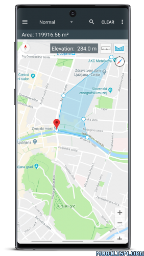
A single tap on the map gives you access to world coordinates. In addition, Map Coordinates offers a full set of tools like distance measurement, current GPS location, history / favorite locations, share location, find location or copy coordinates / address. You can switch between multiple coordinate types like decimal degrees, DMS (degrees, minutes and seconds) or even special types like what3words, MGRS or UTM.

The app is designed to easily determine the coordinates and address of a point on the map and share them with friends via SMS, email or social apps.

When you need to find a location, you can either type / paste the address / coordinates in a search field or enter each coordinate value one by one in it’s own field using the advanced search options. what3words, UTM and MGRS can be searched for only by using the single search field.

The current GPS location is best received while the mobile device is located outdoors. The GPS satellites are easy to be found when there is no interference like buildings or clouds. Even if the device is located indoor, the location can be accurately found through WiFi network but only if the device is connected to that network.

The side drawer menu is used to navigate between different parts of the app like History / Favorites but it is also used to switch the map provider. The available map providers are Google Maps and Open Street Maps, each of them having different map types. Under Open Street Maps there is also a compass available all the time.

Settings can also be accessed from the side navigation drawer. There you have the options to switch between existing coordinates types, change the visibility of the address bar or you can enable the Distance measure tool and the Elevation tool. Elevation displays the altitude of the selected location on the map.

We hope that this app fulfills your needs but if you have any other expectations, please don’t hesitate to contact us and we will try to help you out.

What’s New:
– Increase the download speed for offline maps
– Multiple bugfixes

Mod Info:
  • MGRS coordinates type unlocked;
  • UMT coordinates type unlocked;
  • Remove Ads unlocked;
  • Measurement Tools unlocked;
  • Disabled / Removed unwanted Permissions + Receivers + Providers + Services;
  • Optimized and zipaligned graphics and cleaned resources for fast load;
  • Ads Permissions / Services / Providers removed from AndroidManifest;
  • Ads links removed and invokes methods nullified;
  • Ads layouts visibility disabled;
  • Google Maps Location works;
  • Google Play Store install package check disabled;
  • Debug code removed;
  • Remove default .source tags name of the corresponding java files;
  • Analytics / Crashlytics / Firebase disabled;
  • No active trackers or advertisements;
  • Languages: Full Multi Languages;
  • CPUs: armeabi-v7a, arm64-v8a, x86, x86_x64;
  • Screen DPIs: 120dpi, 160dpi, 240dpi, 320dpi, 480dpi, 640dpi;
  • Original package signature changed;
  • Release by Balatan.


This app has no advertisements

More Info:
https://play.google.com/store/apps/details?id=sands.mapCoordinates.android

Download Instructions:
https://ouo.io/n8iLJv

Mirrors:
https://ouo.io/ze24t8
https://ouo.io/PGGKUsS
https://ouo.io/kKz2Mp
https://ouo.io/eXXBRv

Trouble downloading? Read This.

Download Compass & Altimeter v3.8.1 [Premium] [Mod Extra]

Compass & Altimeter v3.8.1 [Premium] [Mod Extra]
Requirements: 5.0+
Overview: A simple and easy to use Compass to retrieve useful information about your current position such as true Geographic north and true altitude also when offline or in flight mode.

Image

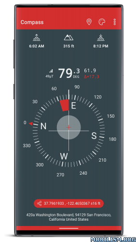
• Free and without Ads
• Geographic north using magnetic declination
• True altitude above mean sea level (AMSL)
• Sunrise & Sunset time
• Azimut angles in deg, grad, mrad, gon
• Various dials and color themes (including high contrast)
• Angle measurement (with dials including measuring capabilities)
• Bubble Level functionnality (available in iPhone dial)
• Use EGM96 as the geoid reference for computing altitude
• Latitude & Longitude in MGRS format
• Latitude & Longitude in UTM format
• Latitude & Longitude in DD, DMM or DMS format
• Magnetic field strength to detect potential perturbations
• Sensor accuracy
• Address of your current location (requires data connectivity)

Compass better works outside where magnetic perturbations are low. Magnetic closure cell phone cases may also disrupt the accuracy of the compass.

EGM96 (Earth Gravitational Model) is used as the geoid reference to compute true altitude above sea level from data collected by the GPS sensor. UTM (Universal Transverse Mercator) is a system for assigning coordinates to locations on the surface of the Earth.

Have fun !

What’s New:
Added the ability to track altitude from your connected watch or phone’s lock screen via a persistent notification.

Mod Info:
  • Premium / Paid features unlocked;
  • Disabled / Removed unwanted Permissions + Receivers + Providers + Services;
  • Optimized and zipaligned graphics and cleaned resources for fast load;
  • Ads Permissions / Services / Providers removed from AndroidManifest;
  • Ads links removed and invokes methods nullified;
  • Ads layouts visibility disabled;
  • Google Maps Location works;
  • AOSP compatible;
  • Google Play Store install package check disabled;
  • Debug code removed;
  • Remove default .source tags name of the corresponding java files;
  • Analytics / Crashlytics / Firebase disabled;
  • Languages: Full Multi Languages;
  • CPUs: armeabi-v7a, arm64-v8a, x86, x86_64;
  • Screen DPIs: 160dpi, 240dpi, 320dpi, 480dpi, 640dpi;
  • Original package signature changed;
  • Release by Balatan.


This app has no advertisements

More Info:
https://play.google.com/store/apps/details?id=net.androgames.compass

Download Instructions:
https://ouo.io/n8iLJv

Mirrors:
https://ouo.io/ynQN9Sv
https://ouo.io/1uSVJD
https://ouo.io/hB5M0g
https://ouo.io/42vvYw

Trouble downloading? Read This.

Download Aqua Map Boating v31.8 [Unlocked]

Aqua Map Boating v31.8 [Unlocked]
Requirements: 8.0+
Overview: An app to satisfy all your Fishing and Boating’s needs, developed with the help of professional fishermen. You will download the best nautical charts and enjoy your new fishing season.

Image Image

An app to satisfy all your Fishing and Boating’s needs, developed with the help of professional fishermen. You will download the best nautical charts and enjoy your new fishing season. Press the RECORD button, put the phone in your pocket and record your fishing trolling track….and much more.

►► Features:
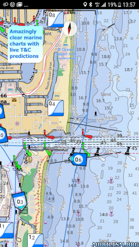
• Amazingly clear marine maps
• Only Official nautical charts (see list below) from National Hydrographic Offices
• You can download the maps on the device, to be used later without any internet connection
• Tides & Currents Prediction plus the ability to simulate their trend on the screen (now only in US)
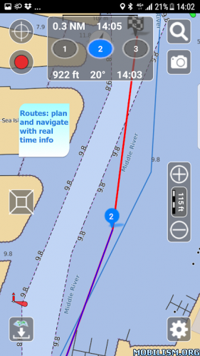
• Plan and navigate your ROUTE with real-time information on next waypoint
• Expand your horizons with mapXpan (patent pending)
• Easy to use
• ActiveCaptain community integration
• Optimized battery usage with battery consumption monitoring
• Share and load tracks, markers, routes and pictures in various formats (KMZ and GPX)
• Add the Satellite images as overlay of your maps
• Measure distances on the map.
• Query map objects with your finger tip

► MAPS
Aqua Map lets you download the best Nautical charts with depth contours, buoys, lights, etc. and all it is necessary to enjoy your best marine experience. You can download the maps at home within your device and then use them on the boat without any Internet connection.
We use only official Hydrographic offices: NOAA, CHS, BA, BSH, etc.
Available areas: US, Canada, Caribbean, Brazil, Argentina, UK, Ireland, Spain, Portugal, Italy, Germany, Netherlands, Belgium, Croatia, Estonia, Malta, Seychelles, Maldives, Emirates, South Africa, New Zealand.

► TIDES & CURRENTS
You can calculate the prediction for more than 5800 stations in the US. You can also have a simulation of the T&C trend on the map by minute wise precision.

► mapXpan
This map mode will greatly extend your display; you will have the details you need for a safe navigation seamlessly integrated with a large overview area. Using this mode you will see a map 64 times larger without losing any detail in the center part of the screen.

► ROUTES and WAYPOINTS
Plan your trip, insert and edit waypoints. Navigate your route and monitor distance, time (ETA) and direction toward your next waypoint or your final destination

► LOADING and SHARING
With Aqua Map you can share your favorite’s markers or send an email with your last daily track. Not only, you can also load any KML, KMZ, GPX you can find over the internet or receive from your friends.

► ENJOY ActiveCaptain Community
Join the community of more than 100.000 boaters who write reviews, update data and provide up to date hazard information.
Read and contribute reviews and rating about marinas, shared local boating knowledge, anchorage and hazards

Terms of Service: http://www.globalaquamaps.com/Acknowledge.html

– All Charts & Features Unlocked
– Not all regions/areas have maps available so don’t report if no maps are available for you.


What’s New:
• Improvements and bug fixing

This app has no advertisements

More Info:
https://play.google.com/store/apps/details?id=com.gec.MarineApp.WorldViewerLite

Download Instructions:
https://ouo.io/vZKR1Y

Mirror:
https://ouo.io/D5cqnAN

Trouble downloading? Read This.