Download Altimeter v4.7.04 [Premium] [Mod Extra]

Altimeter v4.7.04 [Premium] [Mod Extra]
Requirements: 4.1+
Overview: Altimeter is a smart tracking devices, used to altitude measure. It is perfect app for people who love hiking, skiing, mountain biking and other outdoor activities.

Image

Any time and with high precision you can check altitude, elevation or localization coordinates. It works online and offline.

This altimeter app, to measure altitude uses:
– GPS satellites triangulation – works without internet connection,
– barometer pressure sensor (if available in your device) – high accurate data; if internet connection is available it calibrates itself to improve accuracy,
– online networks location services (wifi and other) – need internet connection.

You can use each sensor separate or all together.

App altitude meter includes the following features:
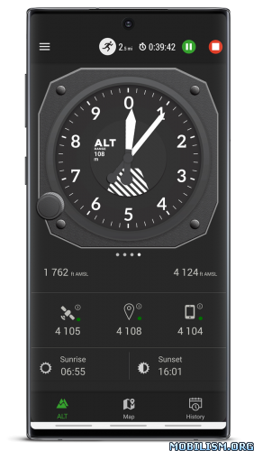
– accurate measurement of altitude – indication in meters or feet
– record of: lowest (low), highest (max) altitude
– smart mini compass
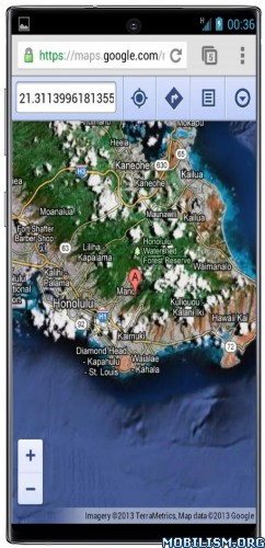
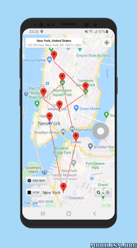
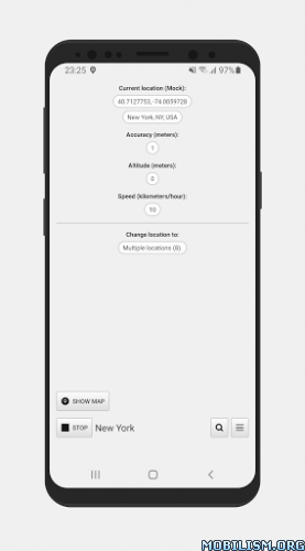
– full GPS coordinates – latitude and longitude
– current localization name and state
– results of measurements are shown in the chart
– ability to stop and record the results of measurements at any time
– invert background color (black and white)
– share summit top altitude pics – share photo with altitude to your friends or export them to save place.

All features are free. You can remove all ads from app by purchase "no ads".

Enjoy with this altimeter app !

What’s New:
Copying and Sharing geographic coordinates in Premium
Added free 7-days Premium trial
Fixed problems with network altitude downloading
Bug fixes and stability improvements
Improved location filtering algorithm for the best accuracy
Fixed problems with GPX export
Export and import all Altimeter data from/to another devices
Fixed altitude and other data from GPS on Android 10 and some other devices models
Improving altitude determination based on location

Mod Info:

  • Premium / Paid features unlocked;
  • Disabled / Removed unwanted Permissions + Receivers + Providers + Services;
  • Optimized and zipaligned graphics and cleaned resources for fast load;
  • Ads Permissions / Services / Providers removed from Android.manifest;
  • Ads links removed and invokes methods nullified;
  • Ads layouts visibility disabled;
  • Google Maps Location works;
  • Google Play Store install package check disabled;
  • Debug code removed;
  • Remove default .source tags name of the corresponding java files;
  • Analytics / Crashlytics / Firebase disabled;
  • Languages: Full Multi Languages;
  • CPUs: universal architecture;
  • Screen DPIs: 160dpi, 240dpi, 320dpi, 480dpi, 640dpi;
  • Original package signature changed;
  • Release by Balatan.

This app has no advertisements

More Info:
https://play.google.com/store/apps/details?id=com.exatools.altimeter

Download Instructions:
https://ouo.io/VmqlTt

Mirrors:
https://ouo.io/8zH3hhi
https://ouo.io/sliFcI
https://ouo.io/H93qSf
https://ouo.io/TApiJa
https://ouo.io/ChwbNtO
https://ouo.io/I2qBTe

Download PPM Commander – GPS status v2.8.2.3 [Pro]

PPM Commander – GPS status v2.8.2.3 [Pro]
Requirements: 4.0.3+
Overview: Connect your external GPS device by USB or bluetooth. Route the GPS position as mock location provider to any navigation app on your phone or tablet.
Show GPS status data like position, height, accuracy, satellites, velocity, etc.

ImageImage

Connect your external GPS device by USB or bluetooth. Route the GPS position as mock location provider to any navigation app on your phone or tablet.
Show GPS status data like position, height, accuracy, satellites, velocity, etc.
You can forward RTK correction data to your high accuracy external device. RTCM data is loaded from the internet by the internal NTRIP client.

The app ist completely free with the exception of the NTRIP-RTCM feature. If you want to forward RTK data from your data provider (e.g. land surveying office) to the external GPS antenna, please license the app. You can fully test the NTRIP feature in advance within the 30 days trial period. You can view received RTCM message-types and coordinate-projection-parameters of the RTK data on the RTCM monitor page.

PPM Commander supports devices from ppm GmbH only, eg. ppm-10xx!

The PPM Commander can transform WGS84 coordinates into a local coordinate system like "Gauß-Krueger or UTM" for germany. Additionally you can set a fixed offset to the transformation for further improvement of the calculated local coordinate. If you allow mock locations in the developer options of your android device you can use the position of the external receiver in any application. The preferred way to process the external GPS position in other apps without using "mock locations" is implementing a simple ContentObserver. You can even get the transformed local coordinate and additional informations about the GPS status by using the app as content-provider.

By activating the "mocking" feature (get the position of your external GPS antenna into android) you can use this app for any other navigation-app or for geo-tagging.

Free features
+ GPS Status
+ Satellite list & Sky-Plot with subsystems like GPS, Glonass or Galileo
+ Coordinate-Transformation into local coordinate system
+ Mock location provider (e.g. use your external device for navigation)
+ Log all received NMEA data

You need a license for
+ RTK correction data over internet (NTRIP client)
+ RTCM monitor
+ Android "content provider" feature to access all status data

What’s New:
+ Add extra info to mocking location

This app has credit advertisements

More Info:
https://play.google.com/store/apps/details?id=de.pilablu.gnsscommander

Download Instructions: credit Timozhai
https://ouo.io/29ABxAq

Mirrors:
https://ouo.io/NrnvDA
https://ouo.io/Dt3K4qr

Download Strava: Track Running, Cycling & Swimming v258.11 [Mod]

Strava: Track Running, Cycling & Swimming v258.11 [Mod]
Requirements: 5.0+
Overview: Millions of runners and cyclists use Strava to record their activities, compare performance over time, compete with their community, and share the photos, stories and highlights of their activities with friends.

Image

• Activity Tracking: During and after activity, get key stats like distance, pace, speed, elevation gained and calories burned, as well as an interactive map of your activity
• Training Log: Monitor your training and track your improvement over time
• Route Discovery: Discover new places to run or ride, or follow routes you’ve created with mobile navigation

Connect with Friends and Fellow Athletes
• Social Training: Follow friends, training buddies and pros to view each other’s activities and encourage them with kudos and comments
• Activity Photos: Showcase the best moments of your run or ride
• Friendly Competition: Dig deep and shoot for a top time on segment leaderboards
• Personal Challenge: Participate in monthly Challenges designed to push you further
• Strava on Social: Share activity details on Facebook and Twitter

Pair Your Favorite Technology
• Device Friendly: Strava works with almost all GPS running watches, cycling computers and activity trackers
• Heart Rate: Train with a heart rate monitor for additional performance data

Additional web-only features, including route building, clubs and group activities, are available to all Strava athletes at http://www.strava.com .

Passionate Athletes: Go Premium
• Train for peak performance with personalized coaching
• Get unrivaled live performance feedback during your activity
• Geek out with exclusive and detailed analysis after every activity

These Premium features are available through in-app purchasing.

NOTE ON GPS SUPPORT:
Strava depends on GPS for recording activities. In some devices, the GPS does not work properly and Strava will not record effectively. If your Strava recordings show poor location estimation behavior, please try to update the operating system to the most recent version. There are some devices which have consistently poor performance with no known remedies. On these devices we restrict installation of Strava, for example the Samsung Galaxy Ace 3 and the Galaxy Express 2 . See our support site for more information: https://strava.zendesk.com/entries/2714 … id-device-

What’s New
No changelog.

★★★ MOD ★★★
– Subscription Paid activated
– Maps: sections, routes, saved, recording, saved routes and beacon – working
– Unlock more track – not working
– Login via e-mail
– Original package signature changed
– Multi languages
– CPUs: armeabi-v7a,arm64-v8a, x86, x86_64.

This app has no advertisements

More Info:
https://play.google.com/store/apps/details?id=com.strava&hl=en

Download Instructions: credit cenzo
https://ouo.io/j9UGFUH

Mirrors:
https://ouo.io/3JY3H9
https://ouo.io/zNcapu

Download Coordinate Master v7.8 [Paid]

Coordinate Master v7.8 [Paid]
Requirements: 4.0 and up
Overview: The most comprehensive coordinate converter tool available for Android !. This powerful geodesy app allows you to convert coordinates between many of the world’s coordinate systems, compute geoid offsets, and estimate the current or historic magnetic field for any location.

Image Image

This powerful geodesy app allows you to convert coordinates between many of the world’s coordinate systems, compute geoid offsets, and estimate the current or historic magnetic field for any location. It also includes a calculator tool as well as surveying tools to compute the point scale factor, grid convergence, traverse, inverse, and sun angle. You can also store multiple points and compute boundary length and area on them, or import/export them to CSV files.

The app uses the PROJ4 library and a lookup file containing projection and datum parameters to support over 1700 coordinate systems. Lat/lon, UTM, US coordinate systems (including US State Plane), Australian coordinate systems (including GDA2020), UK coordinate systems (including Ordinance Survey) and many, many others are supported. You can also create your own coordinate systems if you know the parameters.The app also supports affine transformations to allow you to set up local grid systems. See _http://www.binaryearth.net/Miscellaneous/affine.html for details.

The app either takes manual coordinate input or uses your current GPS location. The computed location can be displayed in Google Maps via your web browser with a single button press. It also supports MGRS grid references.

You can export any lat/lon, UTM or transverse Mercator coordinate systems to a HandyGPS datum (.hgd) file for use as a custom datum in HandyGPS.

The magnetic field calculator page computes the Earth’s current or historical magnetic field at a given location. The magnetic declination computed is useful for compass navigation since it represents the difference between true north and magnetic north. Field inclination and total intensity are also computed. This tool uses the International Geomagnetic Reference Field model (IGRF-13). See _http://www.ngdc.noaa.gov/IAGA/vmod/igrf.html for full details. Years from 1900 through to 2025 are supported.

The app can also compute the geoid height offset for a given location, using the EGM96 model. Geoid offset can be subtracted from the height reported by GPS to give your actual height above sea level.

The app also includes a sun angle calculator which can be used to compute the location of the sun in the sky at any location for any date and time.

Online help for the app is available at _http://www.binaryearth.net/CoordinateMasterHelp

A version of this app which allows batch coordinate conversions is now available for Windows. See _http://www.binaryearth.net/CoordinateMaster/Windows

Permissions required: (1) GPS – to determine your location, (2) SD card access – to read and write user projections file.

★ Untouched Paid apk with Original Hash Signature
★ Certificate MD5 digest: 82a8f8eb746f4f194d29621686b21357
★ No changes were applied
➡ Languages: Full Multi Languages
➡ CPU architectures: Universal
➡ Screen DPIs: 120dpi, 160dpi, 240dpi, 320dpi, 480dpi, 640dpi

Whats New:
7.8: Fixed a bug related to coordinate systems with a spherical ellipsoid.

This app has no advertisements

More Info:
https://play.google.com/store/apps/details?id=binaryearth.coordsystool&hl=en

Download Instructions:
https://ouo.io/TwxFP4

Mirrors:
https://rapidgator.net/file/109035e067d … 0.apk.html
https://ouo.io/xnUMj3

Download Location Changer (Fake GPS Location with Joystick) v3.09 [PRO]

Location Changer (Fake GPS Location with Joystick) v3.09 [PRO]
Requirements: 4.1 and up
Overview: Change your GPS location using this simple app

Image

Image
* Please read everything from this page before using the app: https://www.netlinkd.com/locationchanger/

* Please note: if the app suddenly stops working or the notification disappears after some time it is probably because it is background restricted in your Battery settings please make sure to allow it to run in the background so it can work properly. Also if you are using Mock locations mode it is possible that some apps may detect that you are using a fake location and you may get an error message saying that they failed to detect your location this is normal and Location Changer still works correctly but unfortunately Android can let apps know if you are using a Mock location. There is not much that can be done about that there are some workarounds and they may have their own limitations please research on the Internet to understand more about that.

* Now it can work as a system app without needing to enable Mock locations. Please search how to make it a system app as it can be different for each device. Also please note that this is a power user feature and we are not responsible if you cause any problems to your device in the process of making it a system app. To enable this mode go to Settings – Working mode – Root (system app). Please note that with Root mode the location may jump back to the real one on some devices – we recommend that you use this mode indoors where there is no GPS signal so it doesn’t interfere. If you don’t wan’t to use it as a system app you will need to enable Mock locations on your device from Developer options for the app to work.

* Joystick: this can be enabled from Settings – Joystick. To set the maximum speed (in km/h) go to Settings – Speed. Double tap on the Joystick and hold it down to drag it to a new preferred position.

* What is "Mock locations"? Mock locations is a hidden setting in Developer options in the Android operating system that allows a device owner to set any GPS location for testing purposes. To enable Developer options go to your device Settings – About and tap Build number 7 times. This may be different on some devices in this case you have to search how to do it for your device. Please use caution by not changing other system settings.

* Now you can add multiple pins on the map and set an interval in seconds to change the location to each pin. Please note that in Android the interval will vary significantly when you turn off your screen/the device goes into sleep mode. To clear the pins tap on Done and then long press on the map or search for a location to set a new single pin.

* Please note that this app does not change your IP address this is not a VPN. Applications/websites that check your location based on your IP address may still detect your real location.

* Now you can access the Android system Developer options from the menu in the lower right.

* Now it works in Battery saving mode too (no GPS) so all Location modes work now. This mode does not work with Root mode.

* Please note: to disable Mock locations on your device you will need to do it from Developer options. You normally do not need to disable it back but some apps may not like it that you have it enabled as they can detect this. Also it is important to tap on the Stop button before you disable Mock locations to get your real location back.

Please use this app responsibly.

Please note that we are not responsible in any way how users choose to use this tool.

What’s New:
– Improvements and fixes.
– Added Pause/Resume/Restart for multiple pins/locations.

Premium Unlocked
•Maps/Location works
•Debug info removed
•Mod by Srajawwal09

This app has no advertisements

More Info:
https://play.google.com/store/apps/details?id=com.locationchanger

Download Instructions:
https://ouo.io/labIfKZ

Mirror:
https://ouo.io/Wm0aAM
https://ouo.io/VA4UQI