Download bergfex Hiking & Tracking v4.5.8 [Pro]

bergfex Hiking & Tracking v4.5.8 [Pro]
Requirements: 8.0+
Overview: The perfect ALL-IN-ONE tool for all your outdoor activities. Use it for Hiking, Mountain Biking, Running, Cycling, Climbing, Nordic walking, Ski Tours, Fitness and much more.

Image

Outdoor Tracking & Tours App
The perfect ALL-IN-ONE tool for all your outdoor activities. Use it for Hiking, Mountain Biking, Running, Cycling, Climbing, Nordic walking, Ski Tours, Fitness and much more.
Your Tool for tracking and planing your tours:
● detailed topographical maps for Europe
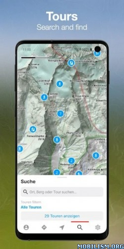
● more than 70.000 GPS-Tours
● great search functionality
● offline maps (PRO-Version)
● tool for planning your personal tours
● connectivity for bluetooth watches or chest straps
● websync with myBergfex account
● save your favourite tours
● GPX export/import

• Use the Tours App as a activity or fitness tracker (with pulse recording function and pulse zones in pro version).
• Choose one of more than 70.000 detailed hiking tours, mountainbike tours, running courses, ski tours, cycling routes and much more – inform yourself about length, height, duration, etc. to get a detailed description with photos of the tour (if you are going to hike or ride a selected tour you can use our way-leaving-function to get a warning if you once missed the right way).
• Download your maps offline on your smartphone (PRO Version) so you will not need a mobile or internet connection for navigation any more.
• Plan your personal tour from any start point to your preferred top of the mountain (this is also possible with different waypoints – in PRO Version).
• All your activities and tours-favourites are synced with your (optional) myBergfex account and you will have a backup and synced tours across all your devices.
• With the favourite functionality you have easy access to your most liked tours.

PRO-Features:
You can use all PRO-Features for one week for free!
● detailed topographical maps for Europe (with higher zoom levels)
● slope steepness overlay (to display the steepness >30°,35°,40°,45°)
● ÖK50 (detailed Austrian Mountain Map)
● offline maps (for navigation with no mobile or internet connection)
● sat-view overlay function (with additional information in the maps)
● routing function with waypoints
● pulse measurement with zones
● no advertising in PRO-Version

The Bergfex Tours App is your perfect partner for all your outdoor activities (Mountain Biking, Running, Cycling, Climbing, Nordic Walking, Ski Tours, Fitness and much more).

Note: Continued use of GPS running in the background can dramatically decrease battery life.

Terms and Conditions: http://www.bergfex.at/agb/
Privacy Policy: http://www.bergfex.at/datenschutz/

What’s New:
Having questions or problems with our app? Contact us via email: android-tours@bergfex.at

– UX/UI: New login and registration UI including dark mode support
– Tracking: Pause button is now disabled by default and can be re-enabled via settings
– Other: bug fixes and general stability improvements

This app has no advertisements

More Info:
https://play.google.com/store/apps/details?id=com.bergfex.tour

Download Instructions:
https://ouo.io/IJKlQF

Mirror:
https://ouo.io/YIQNhd

Download GPS Attitude v1.16 [Paid]

GPS Attitude v1.16 [Paid]
Requirements: 4.2+
Overview: GPS Attitude displays and logs GPS position and heading, pitch and roll of an Android phone or tablet.

ImageImage

GPS Attitude displays and logs GPS position and heading, pitch and roll of an Android phone or tablet.

The log files can be accessed as using Android File Transfer. The logged data can also be sent via TCP.

An XYZ offset can be applied to the GPS position. Corrections can be applied to the heading, pitch and roll data.

This App uses GPS to determine the position of your smart phone. Therefore GPS must be enabled in the Android Settings. The smart phone should be used away from tall buildings to ensure that a strong GPS signal is received from the GPS satellites.

Disclaimer: The data shown in the App is only as accurate as the GPS position and heading data.

What’s New:
Minor changes.

This app has no advertisements

More Info:
https://play.google.com/store/apps/details?id=com.bergin_it.gpsattitude&hl=en

Download Instructions:
https://ouo.io/s1SrZf

Mirrors:
https://ouo.io/pxcOoS
https://ouo.io/Nn9NPu

Download GPS Scatter Plot v1.16 [Paid]

GPS Scatter Plot v1.16 [Paid]
Requirements: 4.2+
Overview: GPS Scatter Plot allows GPS positions to be collected over time to determine a more accurate GPS position of a single location.

ImageImage

GPS Scatter Plot allows GPS positions to be collected over time to determine a more accurate GPS position of a single location.

During logging the GPS positions are displayed on the screen. When logging is stoopped the average position is displayed.

The GPS positions can be logged to file. A snapshot of the result screen can also be saved.

This App uses GPS to determine the position of your smart phone. Therefore GPS must be enabled in the Android Settings. The smart phone should be used away from tall buildings to ensure that a strong GPS signal is received from the GPS satellites.

Disclaimer: The data shown in the App is only as accurate as the GPS position data.

What’s New:
Minor changes

This app has no advertisements

More Info:
https://play.google.com/store/apps/details?id=com.bergin_it.gpsscatterplot&hl=en

Download Instructions:
https://ouo.io/MNmcv3

Mirrors:
https://ouo.io/oTOkwA
https://ouo.io/iVvA2j

Download Fishing & Hunting Solunar Time Pro v3.8.3 [Pro]

Fishing & Hunting Solunar Time Pro v3.8.3 [Pro]
Requirements: 5.0+
Overview: Make your fishing and hunting extremely effective with forecast from Fishing & Hunting Solunar Time!

ImageImage

Based on the Solunar Tables theory application will help you to determine as precisely as possible the feeding of all types of fish and wildlife. Depending on the position of the moon and its phases and the position of the sun you will have the information about best time for fishing or hunting.

Use Fishing & Hunting Solunar Time to plan your trips to fishing or hunting in order to maximize your chances of success! Save your favorite places using Fishing & Hunting Solunar Time for easy access to Solunar Forecasts in this places.

FEATURES:
✓ Location: Auto GPS or Manual Entry
✓ Save favorite locations for future reference
✓ Major & Minor Feeding / Activity Periods
✓ Day Rating
✓ Moon Rise / Moon Set Times
✓ Sunrise / Sunset Times
✓ Day / Month Views
✓ Current Weather and 5-Day Forecast
✓ Calendar for checking solunar data in advance
✓ ***NEW*** Moon phases

Note: All application features avaliable in PRO version. Feel free to buy PRO version using in app purchase.

What’s New:
Changes not stated.

This app has no advertisements

More Info:
https://play.google.com/store/apps/details?id=com.antonnikitin.solunarforecast&hl=en

Download Instructions: credit cenzo
https://ouo.io/P6xsGH

Mirrors:
https://ouo.io/QnUqEb
https://ouo.io/MUDzWo

Download Mock Locations (fake GPS path) v1.98 [Pro]

Mock Locations (fake GPS path) v1.98 [Pro]
Requirements: 4.4+
Overview: Mock Locations allows you to fake information about the location of your phone by GPS and network operator.

Image

Mock Locations allows you to fake information about the location of your phone by GPS and network operator.

You simply navigate the route on the map and press the "Go!" to have all of the application on your phone to give fake information about the location.

This will help in the development of applications or if you want to, no one knew where you are really.

Attention! Before purchasing the full version of the application check the performance on your device. For this purpose there is a free trial period of 24 hours after installing the app. During this time, you can use the premium features (Hide the application using "Hide Mock Locations", or move the app to the system partition and run without setting Allow mock location). Buy the full version only after making sure that my application works correctly on your device.

On devices with Root access can use the app without a tick "Allow mock locations". (The free version of the application, this function is available for 24 hours after installation.)

To do this you need to move the application to the system partition. This is most easily done by using "System App Converter" program (_https://play.google.com/store/apps/details?id=com.appzdevelopers.sysappconverterf).

Just move the application to the system partition can be manually (Using Root Explorer):
On Android 2.3.3 – 4.3: move the file "ru.gavrikov.mocklocations.apk" from the folder "/data/app" in the folder "/system/app" and reboot the device.
On Android 4.4 – 4.4.4: move the file "ru.gavrikov.mocklocations.apk" from the folder "/data/app" in the folder in the folder "/system/priv-app" and reboot the device.

Even you can hide Mock Locations app work on other applications (in this case they will not see what is on tick "Allow mock locations"). This can be done with the help of my application Hide Mock Locations (_https://play.google.com/store/apps/details?id=ru.gavrikov.hidemocklocations).Attention!!! It works through the Xposed framework.

There are times when your jump coordinates to the actual location. This happens on some devices after the application was transferred to the system partition.
First solution:
In the setting of the device to enter in Location tab and turn off location for wireless networks. And use the application in areas where there is no real GPS signal.
Second solution:
Step 1: Completely delete the app "Mock Locations" from the device.
Step 2: Re-install it from Google Play Market.
Step 3: The developer settings, enable "Allow mock locations".
Step 4: Install my application "Hide Mock Locations" (it works through the Xposed Framework).
Step 5: Install the Xposed Framework.
Step 6: Open Xposed. Activate module "Hide Mock Locations". Reload this device.
Step 7: Open the application "Hide Mock Locations". Choose from any application to hide the setting "Allow mock locations"
Step 8: Close all applications or reboot your device.
Step 9: Use the "Mock Locations" application.

Features:
– Emulation GPS location and according to the service provider.
– Ability to create a route on roads.
– Ability to set breakpoints and specify the stay in them.
– Ability to set a variable speed.
– Closed route. (Allows you to build a route for movement along a closed path. To do this, lay the route so that the start and end points were near.)
– You can use the braking before bends. (Settings -> Slows down before the turn)
– You can run the emulation location at one point.
– You can hide an application icon from the status bar. (Settings -> Hide Icon)

Thank Levin Faber and Ben Black for translation into German.
Thank Luca Boscaini for the Italian translation.

★ PRO / Paid features unlocked
★ AOSP compatible
★ Google / Location Maps work
★ .source attributes of the corresponding java files removed
★ All Debug code removed
★ Original package signature changed
➡ Languages: Full Multi Languages
➡ CPU architectures: Universal
➡ Screen DPIs: 120dpi, 160dpi, 240dpi, 320dpi, 480dpi, 640dpi

What’s New:
For joystick control added the altitude setting.

This app has no advertisements

More Info:
https://play.google.com/store/apps/details?id=ru.gavrikov.mocklocations&hl=en

Download Instructions:
https://ouo.io/eUUa3Al

Mirror:
https://ouo.io/0eUsWgN
https://ouo.io/JxBuaCm
https://ouo.io/c8t0Hs
https://ouo.io/JN72cW
https://rapidgator.net/file/64036e92f76 … e.apk.html