Download Tools for Google Maps v5.39 [Mod Extra]

Tools for Google Maps v5.39 [Mod Extra]
Requirements: 4.4+
Overview: Tools for Google Maps to highlight, edit and capture maps from Google Maps.

Image

The maps from Google Maps are shown in full screen mode or immersive mode without any object to interfere.

You can add and edit polylines, polygons, rectangles, circles and markers.
You can also add text with colors, resize and rotate them
All colors support transparency.

Others features:
• calculate perimeters and areas of polygons
• calculate distance between two points
• import / export to kml format
• easy command to take a snapshot of the map using the entire screen
• address search function
• support all the gesture from google maps
• from the navigation drawer easy switch from different map mode: normal, satellite, hybrid, terrain
• options to enabled compass, buildings, traffic, indoor
• one touch to enter / leave fullscreen mode
• support immersive mode for Android 4.4 devices or superior

What’s New:
• See in the app

Mod Info:

  • Add removed / disabled;
  • Disabled / Removed unwanted Permissions + Receivers + Providers + Services;
  • Optimized and zipaligned graphics and cleaned resources for fast load;
  • Ads Permissions / Services / Providers removed from Android.manifest;
  • Ads links removed and invokes methods nullified;
  • Ads layouts visibility disabled;
  • Google Maps Location works;
  • Google Play Store install package check disabled;
  • Debug code removed;
  • Remove default .source tags name of the corresponding java files;
  • Analytics / Crashlytics / Firebase disabled;
  • Languages: Full Multi Languages;
  • CPUs: universal architecture;
  • Screen DPIs: 160dpi, 240dpi, 320dpi, 480dpi, 640dpi;
  • Original package signature changed;
  • Release by Balatan.

This app has no advertisements

More Info:
https://play.google.com/store/apps/details?id=com.service.fullscreenmaps

Download Instructions:
https://ouo.io/QY7g9S

Mirrors:
https://ouo.io/2sSoaOZ
https://ouo.io/XJG6K1R
https://ouo.io/S5lruY
https://ouo.io/B7npy2
https://ouo.io/SbVxw5
https://ouo.io/XddbM3
https://ouo.io/OH1lFn

Download Locus Map 3 Classic v3.67.0 [Paid]

Locus Map 3 Classic v3.67.0 [Paid]
Requirements: 5.0+ | Root | Google Play Modded | Lucky Patcher
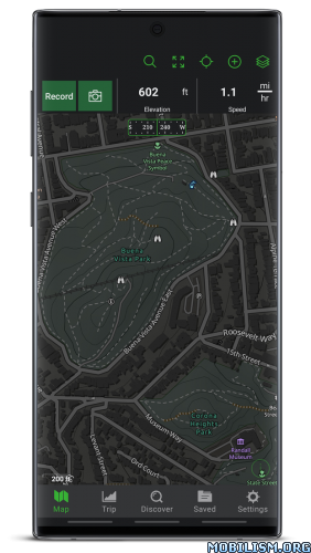
Overview: An ultimate navigation application for all outdoor enthusiasts – hikers, mountain bikers, mountaineers, trail runners, or geocachers. And not only for them, but Locus Map 3 Classic (formerly Locus Map Pro) is widely used also by professionals – explorers, travelers, or rescue squads all over the world.

Image Image

An ultimate navigation application for all outdoor enthusiasts – hikers, mountain bikers, mountaineers, trail runners, or geocachers. And not only for them, but Locus Map 3 Classic (formerly Locus Map Pro) is widely used also by professionals – explorers, travelers, or rescue squads all over the world.

Locus Map 3 Classic offers true multi-functionality and flexibility:

• advanced navigation capability, supporting online and offline routing services
• unprecedented choice of premium offline and online maps
• advanced map tools – map overlays, offsets, WMS sources support
• tools for monitoring sports activities – tracking, audio coach, charts, statistics, support of external sensors (GPS, HRM, cadence…)
• worldwide weather forecast 24/7
• sophisticated tools for geocaching • graphic and calculation tools, online/offline logging, support of trackables, Pocket Queries, spoilers…
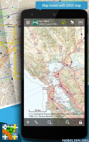
Map portfolio

Offline maps
• LoMaps – OSM-based vector maps of the whole world. Containing themes for hiking, biking, winter sports, road or city use – three LoMaps are for free
• Maps of renowned cartographic publishers:
• Germany, Austria, Italy – Kompass, Outdooractive Summer and Winter, Freytag-Berndt hiking maps
• United States – Accuterra trail maps
• Switzerland – SwissTopo
• United Kingdom – Ordnance Survey (eq. to Landranger and Explorer)
• France – IGN topo and satellite
• Spain – CNIG
• Poland – Compass hiking maps
• Czechia, Slovakia – SHOCart
• other countries – PZS Slovenia, IGN Belgium, Cartographia Hungary, etc.
• support of external maps in SQLite, TAR, MBT, GEMF, Orux, or RMAP formats

Online maps
• World – various OSM based maps
• US – USGS, ChartBundle
• Europe – Outdooractive Summer and Winter, Freytag-Berndt, IGN France and Belgium, Kapsi.fi, Turistautak, Cartographia, Skoterleder, Statkart, Retromap (Russia), UMP and Osmapa.pl (Poland) and many others
• Asia etc. – GSI (Japan), Visicom (former Soviet countries), Navigasi (Indonesia), NzTopoMaps (New Zealand)…
Most of the online maps can be DOWNLOADED for offline use.

WMS maps
• meteorological maps, NASA maps, cadastral maps…

Features:

Navigation and guidance
• turn-by-turn voice navigation with support of online/offline routing services
• beeline guidance to a point (on the map or by compass) or along a route with notifications

Tracks&Routes
• multi-profile track recording
• charts&statistics
• audio coach for efficient workouts
• support of Bluetooth/ANT+ external sensors – HRM, speed/cadence, GPS, NMEA
• route planning and editing tools
• import/export of routes/tracks from/to various formats (KML, KMZ, GPX…) and web services (Strava, Runkeeper, Google Earth, etc…)
• customizable bike computer dashboard

Points
• creating own database – filtering, search, sorting
• import/export in many formats, web services support
• LoPoints – database of OSM POIs

Map tools
• map overlay, calibration, and offsets
• support of various external map formats and coordinate systems
• support of geotagged photos, OSM notes

Search
• addresses online and offline
• W3W addresses
• LoPoints, GeoNames, GNS, and Wikipedia

Geocaching
• downloading geocaches via Geocaching4Locus add-on
• offline and online logging
• support of waypoints, PocketQuery, trackables, spoilers
• graphic and calculation tools

Live tracking
• private or public sharing/monitoring of location in real-time

Other features and tools
• parking assistant, worldwide weather forecast, QR code generator…

Locus Map 3 Classic is highly customizable. Everything can be set according to the user’s needs – the main menu, function panels, dashboards, custom screens… The functionality of the app can be further extended by numerous add-ons – Locus Map Watch, Pebble, RFLKT (connecting with wearables), Augmented reality, GeoGet, Munzee, etc.

This application uses device administrator permission.

★ Untouched Paid apk with Original Hash Signature
★ Certificate MD5 digest: 5abd461b66395862e031a8ab8307fc53
★ No changes were applied
➡ Languages: Full Multi Languages
➡ CPU architectures: arm64-v8a, armeabi-v7a, x86, x86_64
➡ Screen DPIs: 120dpi, 160dpi, 240dpi, 320dpi, 480dpi, 640dpi

Instructions after INSTALL:
https://paste2.org/MCJ5MgMc

What’s New:
*** Locus Map 3.67 ***
– chg: a new backup manager with fine-grained setup
– chg: offline LoMaps rendered by Mapsforge V4 – more details, better clarity, readability and style
– and more

This app has no advertisements

More Info:
https://play.google.com/store/apps/details?id=menion.android.locus.pro&hl=en

Download Instructions:
https://ouo.io/JP95an

Mirrors:
https://ouo.io/7UMSrD
https://ouo.io/O13xPsg
https://ouo.io/FOnj4a
https://ouo.io/y84SBv
https://rapidgator.net/file/7a2ef50c05b … 1.apk.html

Download SG BusLeh: Award Winning v2.3.3 [Pro]

SG BusLeh: Award Winning v2.3.3 [Pro]
Requirements: 5.0+
Overview: A SG Bus Arrival App for both SBS and SMRT bus arrival timing that Singapore Truly Deserves!

Image Image

A SG Bus Arrival App for both SBS and SMRT bus arrival timing that Singapore Truly Deserves!

SG BusLeh won LTA’s Land Transport Excellence Awards 2016 – Most Innovative Solution!

We now also provide SMRT train arrival timing as well as NTU & NUS internal shuttle bus timing!
————-
By downloading or using the app, the terms stated at the bottom of this description will automatically apply to you.

————-
Top Features

1. The only Bus Arrival Timing App that tells you where the bus is!
Simply tap on a bus arrival timing to view the location of the bus on a map!

2. Check you EZ-Link Card Balance anytime, anywhere!
Forget looking for an EZ-Link card machine to check balance. You can now check your EZ-Link card balance using the SG BusLeh app!

3. Got seats? No seat? You will know at a glance!
The only SG Bus App that presents SBS and SMRT bus capacity as simple bars!

4. Magical Unified Search
You can search for anything! These includes bus numbers, postal codes, buildings, road names or even bus-stop ids! Anything would work! No other bus-app comes close.

5. Favourites!!!
All new Favourites feature – simply long-press on any bus-stop to add to Favourites. If you wish to, you may be your own government and rename bus-stops when adding them to Favourites!

6. Bus Routes!
Tap on Bus service number to see bus-routes!

7. Don’t waste time on a bus app!
This app is optimized for speed. We have crafted a mechanism to store the latest timing from LTA on our high-speed servers so there’s no lag!

8. Now available on Android Wear
BusLeh is now available on your Android Wear smartwatches! This feature is only available for paid users.

9. Bus Intervals
BusLeh now shows you the interval between the previous and upcoming bus so that you can better predict if your bus will be crowded by the time it reaches your stop!

10. Notifications!
Let BusLeh monitor your buses for you so you don’t have to. BusLeh will automatically notify you when the bus you want is arriving!

————
Note on App Permissions

The app permission system on Android is really broken. As long as we request for any permission within any permission group, Android would display a permission warning for the entire permission group, which can be confusing.

For example, we request for permission to generate custom bitmap. This permission belongs to the same group as SD card permission, leading to Android warning you about SD card access. Please trust us, we are not so bo liao to be interested in your personal data.

————
Terms Of Use

By downloading or using the app, the terms here will automatically apply to you – you should make sure therefore that you read them carefully before using the app. We are offering you this app to use for your own personal use without cost, and we are not liable for any injuries, "late for work", "late for exams", "bus don’t want to come" or any other form of damages, which can be monetary, emotional or otherwise that may arise from the use of this app. All bus arrival estimates in this app are provided "as-is" by Land Transport Authority, cached on our servers and served to you. We make no guarantee of the accuracy or reliability of bus arrival estimates.

What’s New:
Version 2.3.2:
– Improve app performance

This app has no advertisements

More Info:
https://play.google.com/store/apps/details?id=originally.us.buses

Download Instructions:
https://ouo.io/zPdq3YL

Mirrors:
https://ouo.io/9ACE0O

Download Avia Maps Aeronautical Charts v3.10.8 [Subscribed]

Avia Maps Aeronautical Charts v3.10.8 [Subscribed]
Requirements: 5.0+
Overview: The reliable and straightforward Aviation Maps for Pilots and aerospace enthusiasts around the world. Simply choose any 5 by 5 degree area on earth and download relevant data for offline use.

Image

The reliable and straightforward Aviation Maps for Pilots and aerospace enthusiasts around the world. Simply choose any 5 by 5 degree area on earth and download relevant data for offline use. The map features over 50000 airports and 11000 navaids around the globe, just as airspaces for currently 42 countries on all continents (except Antarctica).

For clarity and commonality to paper charts the map is themed in the style of ICAO Annex 4 (Aeronautical Charts). The app is suited for pre-flight route planning with wind and fuel calculations, as well as in-flight navigation. To get the latest weather for more than 9500 airports it is integrated with Avia Weather.

This is a trial app with full features. After an evaluation period of 30 days you will have to do an in-app purchase of $9.99 (might vary in your currency). There will be no recurring charges.

Countries with Airspace data:
United Kingdom
United States

Australia
Austria
Bahrain
Belgium
Bosnia and Herzegovina
Brazil
Canada
Colombia
Croatia
Czech Republic
Denmark
Finland
France
Germany
Greece
Hungary
Ireland
Israel
Italy
Lao People’s Democratic Republic
Latvia
Lithuania
Luxembourg
Macedonia
Namibia
Nepal
Netherlands
New Zealand
Norway
Poland
Portugal
Romania
Russia
Serbia
Slovakia
Slovenia
South Africa
Spain
Sweden
Switzerland

What’s New:
Bugfix: Fixed error which crashed the app when starting downloads in case the permission to show a download progress notification was never granted.
Minor bugfixes.

This app has no advertisements

More Info:
https://play.google.com/store/apps/details?id=com.mytowntonight.aviamap

Download Instructions:
https://ouo.io/loIF8O

Mirror:
https://ouo.io/Ra6HpA

Download Gaia GPS: Offroad Hiking Maps v2023.5 [Subscribed] [Mod Extra]

Gaia GPS: Offroad Hiking Maps v2023.5 [Subscribed] [Mod Extra]
Requirements: 6.0+
Overview: Navigate, track, and explore with Gaia GPS. Millions of people worldwide use Gaia GPS maps to backpack, hike, hunt, camp, ski, and explore the backroads.

ImageImage

Gaia GPS has been featured in countless publications, including Outside, Backpacker, Trail Runner, and the New York Times.

►► Backpacking

Gaia GPS is first and foremost a backpacking app. View your route using comprehensive topo maps and backpacking map layers, plus up-to-date weather forecast overlays. Then, use the intelligent routing tools to plan trips, mark campsites and points of interest, and measure distance, altitude, and elevation change.

►► Day Hiking

Both a hiking navigation app and a platform for finding hikes, Gaia GPS helps you discover your next adventure. You can also create your own tracks, leave reviews, and contribute to the community-sourced hike database.

►► Hunting

Gaia GPS is the most comprehensive hunting app on the market. Build custom hunting maps by cross-referencing game management units with public and private land parcels. Then, get deep into the wilderness to find solitude, even on opening day, with the Roadless and Roadless/Trailless overlays.

►► Camping and Overlanding

A camping app with weather forecasts, public land data, and community-sourced camping beta, Gaia GPS helps you find a campsite anywhere. View dispersed camping areas on the Public Land overlay, and leave waypoints to create custom camping maps. Reference road maps and MVUMs to plot overland, 4×4, or off-roading routes.

►► Backcountry Skiing and Mountaineering

Apply slope-angle shading and 24-, 48-,and 72-hour Snowfall and Precipitation Forecast overlays to create custom backcountry skiing maps, plan tours, and avoid avalanche terrain. Gaia GPS is the best skiing app for staying safe deep in the backcountry.

►► Mountain Biking

Go farther, faster by mounting Gaia GPS to your handlebars for hands-free navigation. Access mountain biking trail maps on both public and private land with the best mountain biking app on the market.

►► Professional Use: Firefighters, Search and Rescue teams, Land Manager, GIS Techs, and Guides

Gaia GPS is the preferred nav app for outdoor professionals. Quickly route to GPS coordinates, view recent wildfires, and share maps, tracks, and waypoints with your team to get boots on the ground faster. Guides can mark routes, campsites, and water sources, and share hard-to-find approaches and descents with clients and fellow guides.

►► Membership Levels

Free Level – You’ll be limited to the default map source, and you won’t be able to download maps for offline use.
Member Level – As a Member, you can download a worldwide catalog of topo, road, and satellite maps.
Premium Member Level – As a Premium Member, you also get access to these map sources:

• NatGeo Trails Illustrated (including Appalachian Trail, Colorado Trail, and John Muir Trail maps)
• ESRI World Satellite Imagery
• NOAA weather forecasts
• US Private Land Ownership (including owner names and addresses for parcels)
• US Hunting Layers (including GMUs, public land, and recent fires)
• US Motor Vehicle Use Maps (MVUMs)
• France IGN
• Swiss Topo
• Backroads Mapbooks Canada
• Hill-shading, contour-line, slope-angle, and other overlays

► To manage your subscription:
• TURN OFF auto-renewal: https://support.google.com/googleplay/answer/7018481

• Subscriptions automatically renew unless auto-renew is turned off at least 24 hours before the end of the current period. Your Google Play account will be charged for renewal within 24 hours of the end of the current period, and identify the cost of the renewal.

• Your Google Play Account will be charged at confirmation of purchase.

• Visit the following URL to view our Privacy Policy: http://www.gaiagps.com/gaiacloud-terms/

• Visit the following URL for full terms of use: http://www.gaiagps.com/terms_of_use

What’s New:
Please help us improve the best route-planning tool on mobile devices by trying out the freehand draw mode (enable it in Experimental Features). We would love your feedback.

New
– Account Deletion via Settings
– Option in Map Controls to hide 3D button
– Minor visual tweaks to map buttons
– Some measurements in route planner will show to 2 decimal places instead of 1

Fixes
– Issue editing areas created on iOS devices

Mod Info:

  • Premium / Paid features unlocked;
  • Disabled / Removed unwanted Permissions + Receivers + Providers + Services;
  • Optimized and zipaligned graphics and cleaned resources for fast load;
  • Ads Permissions / Services / Providers removed from Android.manifest;
  • Ads links removed and invokes methods nullified;
  • Ads layouts visibility disabled;
  • Google Play Store install package check disabled;
  • Debug code removed;
  • Remove default .source tags name of the corresponding java files;
  • Analytics / Crashlytics / Firebase disabled;
  • Native Sentry code removed and disabled;
  • AOSP compatible mode;
  • Languages: Full Multi Languages;
  • CPUs: armeabi-v7a, arm64-v8a, x86, x86_64;
  • Screen DPIs: 120dpi, 160dpi, 240dpi, 320dpi, 480dpi, 640dpi;
  • Original package signature changed;
  • Release by Balatan.

This app has no advertisements

More Info:
https://play.google.com/store/apps/details?id=com.trailbehind.android.gaiagps.pro

Download Instructions:
https://ouo.io/jCRZrF

Mirrors:
https://ouo.io/8aGMF8Q
https://ouo.io/LJXrNN8
https://ouo.io/A7Uwad
https://ouo.io/aQSKY8A
https://ouo.io/raU6M9B
https://ouo.io/tvG74M
https://ouo.io/Kr4Dlb